Seven Pagodas geodata
Seven Pagodas (Tamil Nadu) is a populated place; located in India in Asia/Kolkata (GMT+5.5) time zone. With population of 12,415 people, there are 2708 cities with bigger population in this country. Compared to other cities in India, 88.1% of cities are located further ↑North; 69.5% of cities are located further ←West and 95.4% of cities have higher elevation than Seven Pagodas. Note1


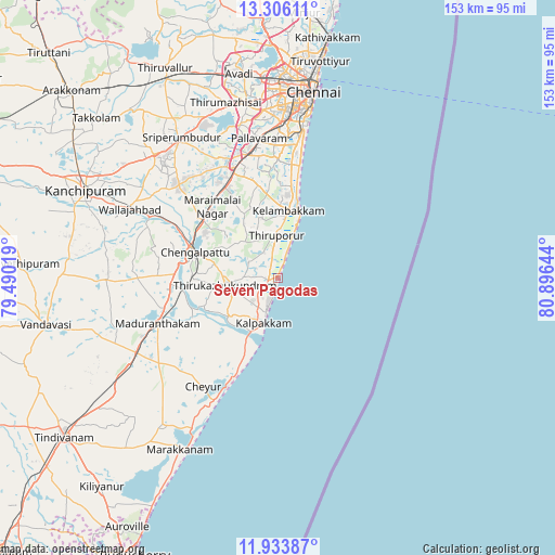
Seven Pagodas GPS coordinates[2]
12° 37' 15.276" North, 80° 11' 35.916" East
| Map corner | latitude | longitude |
|---|---|---|
| Upper-left | 13.30611°, | 79.49019° |
| Center: | 12.62091°, | 80.19331° |
| Lower-right: | 11.93387°, | 80.89644° |
| Map W x H: | 152.6×152.6 km | = 94.8×94.8mi |
| max Lat: | 34.9274° ⇑88.1% North |
| Seven Pagodas: | 12.62091° |
| min Lat: | ⇓11.9% South 8.09008° |
| min Long | Seven Pagodas | max Long |
| 68.82655° | 80.19331° | 96.81° |
| W 69.5%⇐ | ⇒30.5% E |
Elevation
Elevation of Seven Pagodas is 11 m = 36 ft, and this is 284.6 m = 934 ft below average elevation for this country.
| Max E: |
3681 m = 12077 ft | 95.4% |
| Avg. | 295.6 m = 970 ft | |
| Seven Pagodas | 11 m = 36 ft | |
Min E: |
1 m = 3 ft | 4.6% |
See also: India elevation on elevation.city.
Geographical zone
Seven Pagodas is located in North Torrid zone (between Equator and Tropic of Cancer). Distance of this Northern Tropic circle is 1202.6 km =747.3 mi to North.| Distance of | km | miles | from Seven Pagodas |
|---|---|---|---|
| North Pole | 8603.7 | 5346.1 | to North |
| Arctic Circle | 5997.9 | 3726.9 | to North |
| Tropic Cancer | 1202.6 | 747.3 | to North |
| Equator | 1403.3 | 872 | to South |


Nearby cities:
15 places around Seven Pagodas: (largest is in red/bold)
• Cheyyur
36.6 km =22.7 mi,  214°
214°
• Chingleput
24.8 km =15.4 mi,  288°
288°
• Gūduvāncheri
28.8 km =17.9 mi,  329°
329°
• Injambakkam
33.4 km =20.8 mi,  10°
10°
• Karumbākkam
14.3 km =8.9 mi,  309°
309°
• Madambakkam
30.3 km =18.8 mi, 328°
• Madipakkam
38 km =23.6 mi,  0°
0°
• Madurāntakam
35.6 km =22.1 mi,  250°
250°
• Neelankarai
37.2 km =23.1 mi, 11°
• Palavakkam
37.6 km =23.4 mi, 10°
• Perungudi
38.2 km =23.7 mi, 7°
• Singapperumālkovil
25.4 km =15.8 mi, 307°
• Tambaram
34.5 km =21.4 mi,  347°
347°
• Vandalūr
32.6 km =20.3 mi,  337°
337°
• Vengavasal
31 km =19.3 mi,  355°
355°
Sources, notices
• [Note1] Compared only with cities in India existing in our database
• [Src1] Map data: © OpenStreetMap contributors (CC-BY-SA)
• [Src2] Other city data from geonames.org with taken over terms of usage.
• [Src3] Geographical zone / Annual Mean Temperature by Robert A. Rohde @ Wikipedia
