Cheyyur geodata
Cheyyur (Tamil Nadu) is a populated place; located in India in Asia/Kolkata (GMT+5.5) time zone. With population of 11,060 people, there are 2826 cities with bigger population in this country. Compared to other cities in India, 88.8% of cities are located further ↑North; 67.8% of cities are located further ←West and 92.8% of cities have higher elevation than Cheyyur. Note1


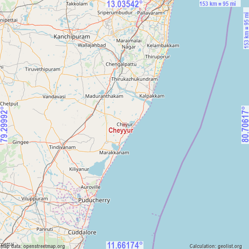
Cheyyur GPS coordinates[2]
12° 20' 58.128" North, 80° 0' 10.944" East
| Map corner | latitude | longitude |
|---|---|---|
| Upper-left | 13.03542°, | 79.29992° |
| Center: | 12.34948°, | 80.00304° |
| Lower-right: | 11.66174°, | 80.70617° |
| Map W x H: | 152.7×152.7 km | = 94.9×94.9mi |
| max Lat: | 34.9274° ⇑88.8% North |
| Cheyyur: | 12.34948° |
| min Lat: | ⇓11.2% South 8.09008° |
| min Long | Cheyyur | max Long |
| 68.82655° | 80.00304° | 96.81° |
| W 67.8%⇐ | ⇒32.2% E |
Elevation
Elevation of Cheyyur is 14 m = 46 ft, and this is 281.6 m = 924 ft below average elevation for this country.
| Max E: |
3681 m = 12077 ft | 92.8% |
| Avg. | 295.6 m = 970 ft | |
| Cheyyur | 14 m = 46 ft | |
Min E: |
1 m = 3 ft | 7.2% |
See also: India elevation on elevation.city.
Geographical zone
Cheyyur is located in North Torrid zone (between Equator and Tropic of Cancer). Distance of this Northern Tropic circle is 1232.8 km =766 mi to North.| Distance of | km | miles | from Cheyyur |
|---|---|---|---|
| North Pole | 8633.9 | 5364.9 | to North |
| Arctic Circle | 6028 | 3745.6 | to North |
| Tropic Cancer | 1232.8 | 766 | to North |
| Equator | 1373.1 | 853.2 | to South |


Nearby cities:
15 places around Cheyyur: (largest is in red/bold)
• Auroville
43.7 km =27.2 mi,  208°
208°
• Chingleput
38.2 km =23.7 mi,  355°
355°
• Desūr
57.5 km =35.7 mi,  279°
279°
• Gūduvāncheri
55.5 km =34.5 mi,  6°
6°
• Karumbākkam
40.3 km =25 mi, 13°
• Madambakkam
56.1 km =34.9 mi,  4°
4°
• Madurāntakam
22.1 km =13.7 mi,  324°
324°
• Marakkanam
18.7 km =11.6 mi,  200°
200°
• Puducherry
49.9 km =31 mi, 202°
• Seven Pagodas
36.6 km =22.7 mi,  34°
34°
• Singapperumālkovil
45.6 km =28.3 mi, 0°
• Tindivanam
39.9 km =24.8 mi,  251°
251°
• Uttiramerūr
39.7 km =24.7 mi, 317°
• Vandavāsi
46.5 km =28.9 mi,  291°
291°
• Wallajahbad
52.8 km =32.8 mi,  338°
338°
Sources, notices
• [Note1] Compared only with cities in India existing in our database
• [Src1] Map data: © OpenStreetMap contributors (CC-BY-SA)
• [Src2] Other city data from geonames.org with taken over terms of usage.
• [Src3] Geographical zone / Annual Mean Temperature by Robert A. Rohde @ Wikipedia
