Chingleput geodata
Chingleput (Tamil Nadu) is a populated place; located in India in Asia/Kolkata (GMT+5.5) time zone. With population of 65,689 people, there are 664 cities with bigger population in this country. Compared to other cities in India, 87.9% of cities are located further ↑North; 67.6% of cities are located further ←West and 76.5% of cities have higher elevation than Chingleput. Note1


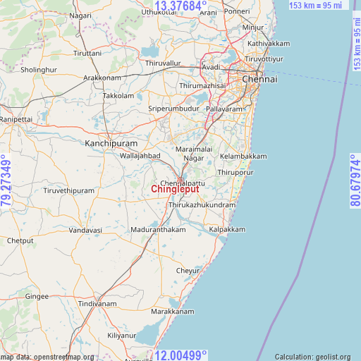
Chingleput GPS coordinates[2]
12° 41' 30.624" North, 79° 58' 35.796" East
| Map corner | latitude | longitude |
|---|---|---|
| Upper-left | 13.37684°, | 79.27349° |
| Center: | 12.69184°, | 79.97661° |
| Lower-right: | 12.00499°, | 80.67974° |
| Map W x H: | 152.5×152.5 km | = 94.8×94.8mi |
| max Lat: | 34.9274° ⇑87.9% North |
| Chingleput: | 12.69184° |
| min Lat: | ⇓12.1% South 8.09008° |
| min Long | Chingleput | max Long |
| 68.82655° | 79.97661° | 96.81° |
| W 67.6%⇐ | ⇒32.4% E |
Elevation
Elevation of Chingleput is 61 m = 200 ft, and this is 234.6 m = 770 ft below average elevation for this country.
| Max E: |
3681 m = 12077 ft | 76.5% |
| Avg. | 295.6 m = 970 ft | |
| Chingleput | 61 m = 200 ft | |
Min E: |
1 m = 3 ft | 23.5% |
See also: Chingleput elevation on elevation.city.
Geographical zone
Chingleput is located in North Torrid zone (between Equator and Tropic of Cancer). Distance of this Northern Tropic circle is 1194.7 km =742.4 mi to North.| Distance of | km | miles | from Chingleput |
|---|---|---|---|
| North Pole | 8595.9 | 5341.2 | to North |
| Arctic Circle | 5990 | 3722 | to North |
| Tropic Cancer | 1194.7 | 742.4 | to North |
| Equator | 1411.2 | 876.9 | to South |


Nearby cities:
15 places around Chingleput: (largest is in red/bold)
• Dūsi
33.6 km =20.9 mi,  286°
286°
• Gūduvāncheri
19.3 km =12 mi,  28°
28°
• Kanchipuram
34 km =21.1 mi,  297°
297°
• Karumbākkam
12.5 km =7.8 mi,  84°
84°
• Madambakkam
19.4 km =12.1 mi,  23°
23°
• Madurāntakam
22.4 km =13.9 mi,  206°
206°
• Nandambakkam
33.3 km =20.7 mi, 17°
• Seven Pagodas
24.8 km =15.4 mi,  108°
108°
• Singapperumālkovil
8.2 km =5.1 mi, 24°
• Srīperumbūdūr
30.9 km =19.2 mi,  353°
353°
• Tambaram
30.6 km =19 mi, 32°
• Uttiramerūr
25.3 km =15.7 mi,  250°
250°
• Vandalūr
25 km =15.5 mi, 26°
• Vengavasal
31.1 km =19.3 mi,  42°
42°
• Wallajahbad
19.9 km =12.4 mi, 303°
Sources, notices
• [Note1] Compared only with cities in India existing in our database
• [Src1] Map data: © OpenStreetMap contributors (CC-BY-SA)
• [Src2] Other city data from geonames.org with taken over terms of usage.
• [Src3] Geographical zone / Annual Mean Temperature by Robert A. Rohde @ Wikipedia
