Kadambūr geodata
Kadambūr (Tamil Nadu) is a populated place; located in India in Asia/Kolkata (GMT+5.5) time zone. With population of 4,512 people, there are 3359 cities with bigger population in this country. Compared to other cities in India, 98.8% of cities are located further ↑North; 52.9% of cities are located further →East and 69.3% of cities have higher elevation than Kadambūr. Note1


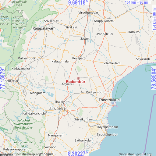
Kadambūr GPS coordinates[2]
8° 59' 50.604" North, 77° 51' 42.876" East
| Map corner | latitude | longitude |
|---|---|---|
| Upper-left | 9.69118°, | 77.15879° |
| Center: | 8.99739°, | 77.86191° |
| Lower-right: | 8.30227°, | 78.56504° |
| Map W x H: | 154.4×154.4 km | = 95.9×95.9mi |
| max Lat: | 34.9274° ⇑98.8% North |
| Kadambūr: | 8.99739° |
| min Lat: | ⇓1.2% South 8.09008° |
| min Long | Kadambūr | max Long |
| 68.82655° | 77.86191° | 96.81° |
| W 47.1%⇐ | ⇒52.9% E |
Elevation
Elevation of Kadambūr is 96 m = 315 ft, and this is 199.6 m = 655 ft below average elevation for this country.
| Max E: |
3681 m = 12077 ft | 69.3% |
| Avg. | 295.6 m = 970 ft | |
| Kadambūr | 96 m = 315 ft | |
Min E: |
1 m = 3 ft | 30.7% |
See also: India elevation on elevation.city.
Geographical zone
Kadambūr is located in North Torrid zone (between Equator and Tropic of Cancer). Distance of Equator is 1000.4 km =621.6 mi to South.| Distance of | km | miles | from Kadambūr |
|---|---|---|---|
| North Pole | 9006.6 | 5596.4 | to North |
| Arctic Circle | 6400.8 | 3977.3 | to North |
| Tropic Cancer | 1605.5 | 997.6 | to North |
| Equator | 1000.4 | 621.6 | to South |


Nearby cities:
15 places around Kadambūr: (largest is in red/bold)
• Alwa Tirunagari
44.3 km =27.5 mi,  168°
168°
• Elāyirampannai
30.6 km =19 mi,  352°
352°
• Ettaiyapuram
21.6 km =13.4 mi,  40°
40°
• Gangaikondān
17.9 km =11.1 mi,  210°
210°
• Kalugumalai
24.1 km =15 mi,  314°
314°
• Kayattār
11.1 km =6.9 mi,  240°
240°
• Korampallam
35.3 km =21.9 mi,  134°
134°
• Kovilpatti
19.4 km =12.1 mi,  2°
2°
• Kulattūr
36.3 km =22.6 mi,  88°
88°
• Sattur
40.5 km =25.2 mi,  9°
9°
• Srivaikuntam
41.3 km =25.7 mi, 172°
• Thoothukudi
39.4 km =24.5 mi, 130°
• Tirunelveli
35.8 km =22.2 mi, 213°
• Vilattikulam
36.6 km =22.7 mi,  65°
65°
• Ālangulam
42.5 km =26.4 mi,  249°
249°
Sources, notices
• [Note1] Compared only with cities in India existing in our database
• [Src1] Map data: © OpenStreetMap contributors (CC-BY-SA)
• [Src2] Other city data from geonames.org with taken over terms of usage.
• [Src3] Geographical zone / Annual Mean Temperature by Robert A. Rohde @ Wikipedia
