Alwa Tirunagari geodata
Alwa Tirunagari (Tamil Nadu) is a populated place; located in India in Asia/Kolkata (GMT+5.5) time zone. With population of 8,887 people, there are 3047 cities with bigger population in this country. Compared to other cities in India, 99.4% of cities are located further ↑North; 51.8% of cities are located further →East and 88.9% of cities have higher elevation than Alwa Tirunagari. Note1


Alwa Tirunagari GPS coordinates[2]
8° 36' 22.86" North, 77° 56' 23.388" East
| Map corner | latitude | longitude |
|---|---|---|
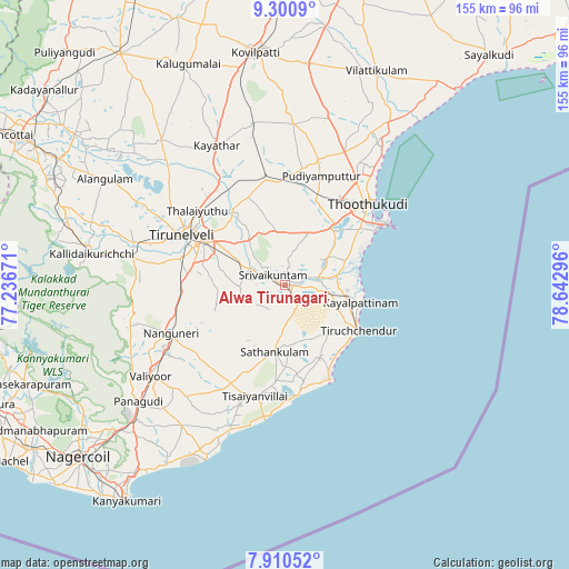
| Upper-left | 9.3009°, | 77.23671° |
| Center: | 8.60635°, | 77.93983° |
| Lower-right: | 7.91052°, | 78.64296° |
| Map W x H: | 154.6×154.6 km | = 96.1×96.1mi |
| max Lat: | 34.9274° ⇑99.4% North |
| Alwa Tirunagari: | 8.60635° |
| min Lat: | ⇓0.6% South 8.09008° |
| min Long | Alwa Tirunagari | max Long |
| 68.82655° | 77.93983° | 96.81° |
| W 48.2%⇐ | ⇒51.8% E |
Elevation
Elevation of Alwa Tirunagari is 20 m = 66 ft, and this is 275.6 m = 904 ft below average elevation for this country.
| Max E: |
3681 m = 12077 ft | 88.9% |
| Avg. | 295.6 m = 970 ft | |
| Alwa Tirunagari | 20 m = 66 ft | |
Min E: |
1 m = 3 ft | 11.1% |
See also: India elevation on elevation.city.
Geographical zone
Alwa Tirunagari is located in North Torrid zone (between Equator and Tropic of Cancer). Distance of Equator is 956.9 km =594.6 mi to South.| Distance of | km | miles | from Alwa Tirunagari |
|---|---|---|---|
| North Pole | 9050.1 | 5623.5 | to North |
| Arctic Circle | 6444.2 | 4004.2 | to North |
| Tropic Cancer | 1649 | 1024.6 | to North |
| Equator | 956.9 | 594.6 | to South |


Nearby cities:
15 places around Alwa Tirunagari: (largest is in red/bold)
• Arumuganeri
17.1 km =10.6 mi,  104°
104°
• Eral
9.4 km =5.8 mi,  76°
76°
• Gangaikondān
33 km =20.5 mi,  327°
327°
• Kayalpattinam
20.2 km =12.6 mi, 101°
• Kayattār
42.2 km =26.2 mi, 334°
• Korampallam
25.1 km =15.6 mi,  41°
41°
• Nanguneri
33.4 km =20.8 mi,  247°
247°
• Sathankulam
18.5 km =11.5 mi,  188°
188°
• Srivaikuntam
3.9 km =2.4 mi,  310°
310°
• Thoothukudi
27.9 km =17.3 mi,  50°
50°
• Tiruchchendur
23.1 km =14.4 mi,  121°
121°
• Tirunelveli
31.2 km =19.4 mi,  295°
295°
• Tisaiyanvilai
31 km =19.3 mi, 194°
• Udangudi
22 km =13.7 mi,  153°
153°
• Vadakku Valliyūr
43.8 km =27.2 mi,  235°
235°
Sources, notices
• [Note1] Compared only with cities in India existing in our database
• [Src1] Map data: © OpenStreetMap contributors (CC-BY-SA)
• [Src2] Other city data from geonames.org with taken over terms of usage.
• [Src3] Geographical zone / Annual Mean Temperature by Robert A. Rohde @ Wikipedia
