Thoothukudi geodata
Thoothukudi (Tamil Nadu) is a populated place; located in India in Asia/Kolkata (GMT+5.5) time zone. With population of 410,760 people, there are 113 cities with bigger population in this country. Compared to other cities in India, 99.1% of cities are located further ↑North; 50.3% of cities are located further ←West and 99.9% of cities have higher elevation than Thoothukudi. Note1


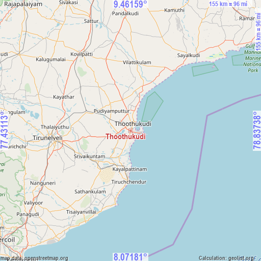
Thoothukudi GPS coordinates[2]
8° 46' 2.46" North, 78° 8' 3.3" East
| Map corner | latitude | longitude |
|---|---|---|
| Upper-left | 9.46159°, | 77.43113° |
| Center: | 8.76735°, | 78.13425° |
| Lower-right: | 8.07181°, | 78.83738° |
| Map W x H: | 154.5×154.5 km | = 96×96mi |
| max Lat: | 34.9274° ⇑99.1% North |
| Thoothukudi: | 8.76735° |
| min Lat: | ⇓0.9% South 8.09008° |
| min Long | Thoothukudi | max Long |
| 68.82655° | 78.13425° | 96.81° |
| W 50.3%⇐ | ⇒49.7% E |
Elevation
Elevation of Thoothukudi is 2 m = 7 ft, and this is 293.6 m = 963 ft below average elevation for this country.
| Max E: |
3681 m = 12077 ft | 99.9% |
| Avg. | 295.6 m = 970 ft | |
| Thoothukudi | 2 m = 7 ft | |
Min E: |
1 m = 3 ft | 0.1% |
See also: Thoothukudi elevation on elevation.city.
Geographical zone
Thoothukudi is located in North Torrid zone (between Equator and Tropic of Cancer). Distance of Equator is 974.8 km =605.7 mi to South.| Distance of | km | miles | from Thoothukudi |
|---|---|---|---|
| North Pole | 9032.2 | 5612.3 | to North |
| Arctic Circle | 6426.3 | 3993.1 | to North |
| Tropic Cancer | 1631.1 | 1013.5 | to North |
| Equator | 974.8 | 605.7 | to South |


Nearby cities:
15 places around Thoothukudi: (largest is in red/bold)
• Alwa Tirunagari
27.9 km =17.3 mi,  230°
230°
• Arumuganeri
22.6 km =14 mi,  192°
192°
• Eral
19.9 km =12.4 mi,  217°
217°
• Ettaiyapuram
44.8 km =27.8 mi,  339°
339°
• Gangaikondān
40.2 km =25 mi,  284°
284°
• Kadambūr
39.4 km =24.5 mi,  310°
310°
• Kayalpattinam
21.8 km =13.5 mi,  184°
184°
• Kayattār
44.4 km =27.6 mi,  296°
296°
• Korampallam
4.8 km =3 mi, 280°
• Kulattūr
27 km =16.8 mi,  13°
13°
• Sathankulam
43.6 km =27.1 mi,  213°
213°
• Srivaikuntam
28.8 km =17.9 mi,  237°
237°
• Tiruchchendur
30.1 km =18.7 mi, 183°
• Udangudi
39.3 km =24.4 mi,  197°
197°
• Vilattikulam
40.7 km =25.3 mi,  4°
4°
Sources, notices
• [Note1] Compared only with cities in India existing in our database
• [Src1] Map data: © OpenStreetMap contributors (CC-BY-SA)
• [Src2] Other city data from geonames.org with taken over terms of usage.
• [Src3] Geographical zone / Annual Mean Temperature by Robert A. Rohde @ Wikipedia
