Ettaiyapuram geodata
Ettaiyapuram (Tamil Nadu) is a populated place; located in India in Asia/Kolkata (GMT+5.5) time zone. With population of 12,956 people, there are 2661 cities with bigger population in this country. Compared to other cities in India, 98.6% of cities are located further ↑North; 51.5% of cities are located further →East and 76.1% of cities have higher elevation than Ettaiyapuram. Note1


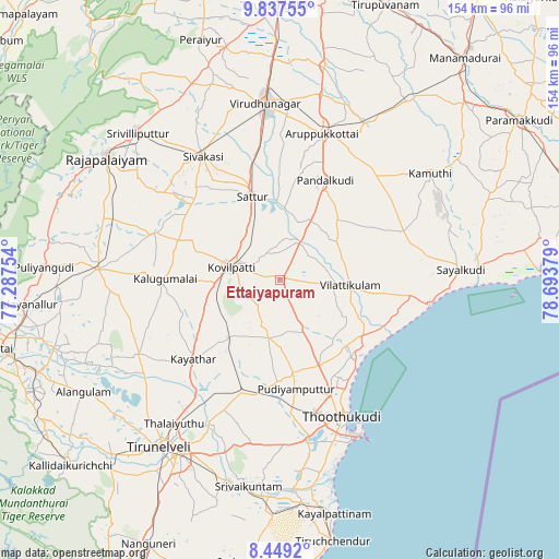
Ettaiyapuram GPS coordinates[2]
9° 8' 38.58" North, 77° 59' 26.376" East
| Map corner | latitude | longitude |
|---|---|---|
| Upper-left | 9.83755°, | 77.28754° |
| Center: | 9.14405°, | 77.99066° |
| Lower-right: | 8.4492°, | 78.69379° |
| Map W x H: | 154.4×154.4 km | = 95.9×95.9mi |
| max Lat: | 34.9274° ⇑98.6% North |
| Ettaiyapuram: | 9.14405° |
| min Lat: | ⇓1.4% South 8.09008° |
| min Long | Ettaiyapuram | max Long |
| 68.82655° | 77.99066° | 96.81° |
| W 48.5%⇐ | ⇒51.5% E |
Elevation
Elevation of Ettaiyapuram is 63 m = 207 ft, and this is 232.6 m = 763 ft below average elevation for this country.
| Max E: |
3681 m = 12077 ft | 76.1% |
| Avg. | 295.6 m = 970 ft | |
| Ettaiyapuram | 63 m = 207 ft | |
Min E: |
1 m = 3 ft | 23.9% |
See also: India elevation on elevation.city.
Geographical zone
Ettaiyapuram is located in North Torrid zone (between Equator and Tropic of Cancer). Distance of Equator is 1016.7 km =631.7 mi to South.| Distance of | km | miles | from Ettaiyapuram |
|---|---|---|---|
| North Pole | 8990.3 | 5586.3 | to North |
| Arctic Circle | 6384.5 | 3967.1 | to North |
| Tropic Cancer | 1589.2 | 987.5 | to North |
| Equator | 1016.7 | 631.7 | to South |


Nearby cities:
15 places around Ettaiyapuram: (largest is in red/bold)
• Aruppukkottai
42.3 km =26.3 mi,  15°
15°
• Elāyirampannai
23 km =14.3 mi,  307°
307°
• Gangaikondān
39.3 km =24.4 mi,  215°
215°
• Kadambūr
21.6 km =13.4 mi, 220°
• Kalugumalai
31.3 km =19.4 mi,  271°
271°
• Kayattār
32.2 km =20 mi,  227°
227°
• Korampallam
42.5 km =26.4 mi,  164°
164°
• Kovilpatti
13.6 km =8.5 mi,  283°
283°
• Kulattūr
27.2 km =16.9 mi,  125°
125°
• Pudūr
23.1 km =14.4 mi,  44°
44°
• Sattur
24.6 km =15.3 mi,  342°
342°
• Sivakasi
40.1 km =24.9 mi,  328°
328°
• Thoothukudi
44.8 km =27.8 mi, 159°
• Tiruttangal
41.5 km =25.8 mi, 335°
• Vilattikulam
19.3 km =12 mi,  93°
93°
Sources, notices
• [Note1] Compared only with cities in India existing in our database
• [Src1] Map data: © OpenStreetMap contributors (CC-BY-SA)
• [Src2] Other city data from geonames.org with taken over terms of usage.
• [Src3] Geographical zone / Annual Mean Temperature by Robert A. Rohde @ Wikipedia
