Kasrāwad geodata
Kasrāwad (Madhya Pradesh) is a populated place; located in India in Asia/Kolkata (GMT+5.5) time zone. With population of 21,484 people, there are 1937 cities with bigger population in this country. Compared to other cities in India, 55.9% of cities are located further ↑North; 77.5% of cities are located further →East and 53.5% of cities have higher elevation than Kasrāwad. Note1


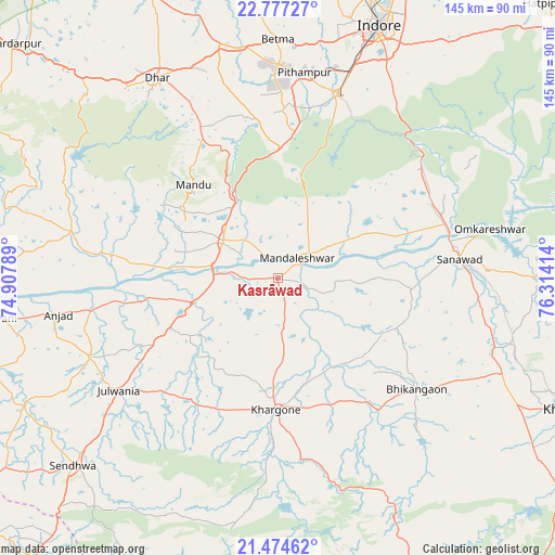
Kasrāwad GPS coordinates[2]
22° 7' 38.82" North, 75° 36' 39.636" East
| Map corner | latitude | longitude |
|---|---|---|
| Upper-left | 22.77727°, | 74.90789° |
| Center: | 22.12745°, | 75.61101° |
| Lower-right: | 21.47462°, | 76.31414° |
| Map W x H: | 144.8×144.8 km | = 90×90mi |
| max Lat: | 34.9274° ⇑55.9% North |
| Kasrāwad: | 22.12745° |
| min Lat: | ⇓44.1% South 8.09008° |
| min Long | Kasrāwad | max Long |
| 68.82655° | 75.61101° | 96.81° |
| W 22.5%⇐ | ⇒77.5% E |
Elevation
Elevation of Kasrāwad is 182 m = 597 ft, and this is 113.6 m = 373 ft below average elevation for this country.
| Max E: |
3681 m = 12077 ft | 53.5% |
| Avg. | 295.6 m = 970 ft | |
| Kasrāwad | 182 m = 597 ft | |
Min E: |
1 m = 3 ft | 46.5% |
See also: India elevation on elevation.city.
Geographical zone
Kasrāwad is located in North Torrid zone (between Equator and Tropic of Cancer). Distance of this Northern Tropic circle is 145.6 km =90.5 mi to North.| Distance of | km | miles | from Kasrāwad |
|---|---|---|---|
| North Pole | 7546.7 | 4689.3 | to North |
| Arctic Circle | 4940.8 | 3070.1 | to North |
| Tropic Cancer | 145.6 | 90.5 | to North |
| Equator | 2460.3 | 1528.8 | to South |


Nearby cities:
15 places around Kasrāwad: (largest is in red/bold)
• Anjad
58.1 km =36.1 mi,  260°
260°
• Betma
62.2 km =38.6 mi,  0°
0°
• Bhikangaon
46.5 km =28.9 mi,  128°
128°
• Dharampuri
27.6 km =17.1 mi,  275°
275°
• Dhāmnod
17.1 km =10.6 mi,  302°
302°
• Dhār
61 km =37.9 mi,  328°
328°
• Indore
69.5 km =43.2 mi,  19°
19°
• Khargone
33.9 km =21.1 mi,  179°
179°
• Maheshwar
5.9 km =3.7 mi,  335°
335°
• Manāwar
55.1 km =34.2 mi, 282°
• Māndleshwar
7.4 km =4.6 mi,  43°
43°
• Mānpur
33.8 km =21 mi, 1°
• Pithampur
53.5 km =33.2 mi,  9°
9°
• Rajpur
53.2 km =33.1 mi,  246°
246°
• Sanāwad
47.5 km =29.5 mi,  83°
83°
Sources, notices
• [Note1] Compared only with cities in India existing in our database
• [Src1] Map data: © OpenStreetMap contributors (CC-BY-SA)
• [Src2] Other city data from geonames.org with taken over terms of usage.
• [Src3] Geographical zone / Annual Mean Temperature by Robert A. Rohde @ Wikipedia
