Manāwar geodata
Manāwar (Madhya Pradesh) is a populated place; located in India in Asia/Kolkata (GMT+5.5) time zone. With population of 27,637 people, there are 1559 cities with bigger population in this country. Compared to other cities in India, 54.9% of cities are located further ↑North; 82% of cities are located further →East and 51.3% of cities have higher elevation than Manāwar. Note1


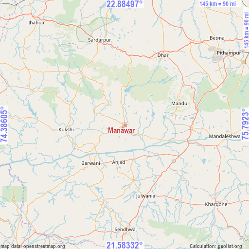
Manāwar GPS coordinates[2]
22° 14' 8.376" North, 75° 5' 21.012" East
| Map corner | latitude | longitude |
|---|---|---|
| Upper-left | 22.88497°, | 74.38605° |
| Center: | 22.23566°, | 75.08917° |
| Lower-right: | 21.58332°, | 75.7923° |
| Map W x H: | 144.7×144.7 km | = 89.9×89.9mi |
| max Lat: | 34.9274° ⇑54.9% North |
| Manāwar: | 22.23566° |
| min Lat: | ⇓45.1% South 8.09008° |
| min Long | Manāwar | max Long |
| 68.82655° | 75.08917° | 96.81° |
| W 18%⇐ | ⇒82% E |
Elevation
Elevation of Manāwar is 195 m = 640 ft, and this is 100.6 m = 330 ft below average elevation for this country.
| Max E: |
3681 m = 12077 ft | 51.3% |
| Avg. | 295.6 m = 970 ft | |
| Manāwar | 195 m = 640 ft | |
Min E: |
1 m = 3 ft | 48.7% |
See also: India elevation on elevation.city.
Geographical zone
Manāwar is located in North Torrid zone (between Equator and Tropic of Cancer). Distance of this Northern Tropic circle is 133.5 km =83 mi to North.| Distance of | km | miles | from Manāwar |
|---|---|---|---|
| North Pole | 7534.7 | 4681.8 | to North |
| Arctic Circle | 4928.8 | 3062.6 | to North |
| Tropic Cancer | 133.5 | 83 | to North |
| Equator | 2472.4 | 1536.3 | to South |


Nearby cities:
15 places around Manāwar: (largest is in red/bold)
• Anjad
21.8 km =13.5 mi,  189°
189°
• Barwāni
29.9 km =18.6 mi,  220°
220°
• Bāg
33.6 km =20.9 mi,  294°
294°
• Dharampuri
28 km =17.4 mi,  110°
110°
• Dhāmnod
39.4 km =24.5 mi,  94°
94°
• Dhār
45.2 km =28.1 mi,  28°
28°
• Jobat
57.2 km =35.5 mi, 290°
• Kasrāwad
55.1 km =34.2 mi,  102°
102°
• Kukshi
34.3 km =21.3 mi,  264°
264°
• Maheshwar
51.7 km =32.1 mi, 97°
• Māndleshwar
59.1 km =36.7 mi, 96°
• Mānpur
58.9 km =36.6 mi,  68°
68°
• Rajpur
33.2 km =20.6 mi,  171°
171°
• Rājgarh
51.4 km =31.9 mi,  343°
343°
• Sendhwa
61.2 km =38 mi,  179°
179°
Sources, notices
• [Note1] Compared only with cities in India existing in our database
• [Src1] Map data: © OpenStreetMap contributors (CC-BY-SA)
• [Src2] Other city data from geonames.org with taken over terms of usage.
• [Src3] Geographical zone / Annual Mean Temperature by Robert A. Rohde @ Wikipedia
