Pithampur geodata
Pithampur (Madhya Pradesh) is a populated place; located in India in Asia/Kolkata (GMT+5.5) time zone. With population of 68,051 people, there are 638 cities with bigger population in this country. Compared to other cities in India, 52.1% of cities are located further ↑North; 76.6% of cities are located further →East and 88.3% of cities have lower elevation than Pithampur. Note1


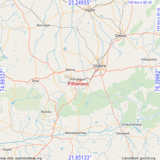
Pithampur GPS coordinates[2]
22° 36' 7.092" North, 75° 41' 47.364" East
| Map corner | latitude | longitude |
|---|---|---|
| Upper-left | 23.24955°, | 74.99337° |
| Center: | 22.60197°, | 75.69649° |
| Lower-right: | 21.95133°, | 76.39962° |
| Map W x H: | 144.3×144.4 km | = 89.7×89.7mi |
| max Lat: | 34.9274° ⇑52.1% North |
| Pithampur: | 22.60197° |
| min Lat: | ⇓47.9% South 8.09008° |
| min Long | Pithampur | max Long |
| 68.82655° | 75.69649° | 96.81° |
| W 23.4%⇐ | ⇒76.6% E |
Elevation
Elevation of Pithampur is 595 m = 1952 ft, and this is 299.4 m = 982 ft above average elevation for this country.
| Max E: |
3681 m = 12077 ft | 11.7% |
| Pithampur | 595 m 1952 ft | |
| Avg. | 295.6 m = 970 ft | |
Min E: |
1 m = 3 ft | 88.3% |
See also: Pithampur elevation on elevation.city.
Geographical zone
Pithampur is located in North Torrid zone (between Equator and Tropic of Cancer). Distance of this Northern Tropic circle is 92.8 km =57.7 mi to North.| Distance of | km | miles | from Pithampur |
|---|---|---|---|
| North Pole | 7494 | 4656.6 | to North |
| Arctic Circle | 4888.1 | 3037.3 | to North |
| Tropic Cancer | 92.8 | 57.7 | to North |
| Equator | 2513.1 | 1561.6 | to South |


Nearby cities:
15 places around Pithampur: (largest is in red/bold)
• Betma
12.6 km =7.8 mi,  318°
318°
• Depālpur
31.9 km =19.8 mi,  330°
330°
• Dewas
54.7 km =34 mi,  42°
42°
• Dharampuri
62 km =38.5 mi,  215°
215°
• Dhāmnod
49.5 km =30.8 mi,  208°
208°
• Dhār
40.9 km =25.4 mi,  268°
268°
• Gautampura
46.5 km =28.9 mi,  336°
336°
• Hātod
21.8 km =13.5 mi,  11°
11°
• Indore
19.1 km =11.9 mi,  47°
47°
• Kasrāwad
53.5 km =33.2 mi,  189°
189°
• Maheshwar
48.7 km =30.3 mi, 193°
• Māndleshwar
47.5 km =29.5 mi,  184°
184°
• Mānpur
20.5 km =12.7 mi,  202°
202°
• Sanāwad
61.2 km =38 mi,  141°
141°
• Sānwer
43.5 km =27 mi,  17°
17°
Sources, notices
• [Note1] Compared only with cities in India existing in our database
• [Src1] Map data: © OpenStreetMap contributors (CC-BY-SA)
• [Src2] Other city data from geonames.org with taken over terms of usage.
• [Src3] Geographical zone / Annual Mean Temperature by Robert A. Rohde @ Wikipedia
