Dhār geodata
Dhār (Madhya Pradesh) is a populated place; located in India in Asia/Kolkata (GMT+5.5) time zone. With population of 82,438 people, there are 533 cities with bigger population in this country. Compared to other cities in India, 52.2% of cities are located further ↑North; 80.2% of cities are located further →East and 85.7% of cities have lower elevation than Dhār. Note1


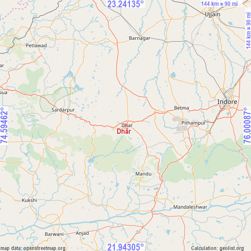
Dhār GPS coordinates[2]
22° 35' 37.428" North, 75° 17' 51.864" East
| Map corner | latitude | longitude |
|---|---|---|
| Upper-left | 23.24135°, | 74.59462° |
| Center: | 22.59373°, | 75.29774° |
| Lower-right: | 21.94305°, | 76.00087° |
| Map W x H: | 144.4×144.4 km | = 89.7×89.7mi |
| max Lat: | 34.9274° ⇑52.2% North |
| Dhār: | 22.59373° |
| min Lat: | ⇓47.8% South 8.09008° |
| min Long | Dhār | max Long |
| 68.82655° | 75.29774° | 96.81° |
| W 19.8%⇐ | ⇒80.2% E |
Elevation
Elevation of Dhār is 559 m = 1834 ft, and this is 263.4 m = 864 ft above average elevation for this country.
| Max E: |
3681 m = 12077 ft | 14.3% |
| Dhār | 559 m 1834 ft | |
| Avg. | 295.6 m = 970 ft | |
Min E: |
1 m = 3 ft | 85.7% |
See also: Dhār elevation on elevation.city.
Geographical zone
Dhār is located in North Torrid zone (between Equator and Tropic of Cancer). Distance of this Northern Tropic circle is 93.7 km =58.2 mi to North.| Distance of | km | miles | from Dhār |
|---|---|---|---|
| North Pole | 7494.9 | 4657.1 | to North |
| Arctic Circle | 4889 | 3037.9 | to North |
| Tropic Cancer | 93.7 | 58.2 | to North |
| Equator | 2512.2 | 1561 | to South |


Nearby cities:
15 places around Dhār: (largest is in red/bold)
• Badnāwar
48.1 km =29.9 mi,  352°
352°
• Betma
34.1 km =21.2 mi,  72°
72°
• Bāg
58.3 km =36.2 mi,  243°
243°
• Depālpur
38 km =23.6 mi,  41°
41°
• Dharampuri
49.6 km =30.8 mi,  174°
174°
• Dhāmnod
46.3 km =28.8 mi,  157°
157°
• Gautampura
49.2 km =30.6 mi,  27°
27°
• Hātod
50.5 km =31.4 mi,  63°
63°
• Indore
56.7 km =35.2 mi,  75°
75°
• Maheshwar
55.2 km =34.3 mi,  147°
147°
• Manāwar
45.2 km =28.1 mi,  208°
208°
• Māndleshwar
59.5 km =37 mi,  141°
141°
• Mānpur
37.8 km =23.5 mi,  118°
118°
• Pithampur
40.9 km =25.4 mi,  88°
88°
• Rājgarh
37.4 km =23.2 mi,  284°
284°
Sources, notices
• [Note1] Compared only with cities in India existing in our database
• [Src1] Map data: © OpenStreetMap contributors (CC-BY-SA)
• [Src2] Other city data from geonames.org with taken over terms of usage.
• [Src3] Geographical zone / Annual Mean Temperature by Robert A. Rohde @ Wikipedia
