Jhalidā geodata
Jhalidā (West Bengal) is a populated place; located in India in Asia/Kolkata (GMT+5.5) time zone. With population of 18,057 people, there are 2193 cities with bigger population in this country. Compared to other cities in India, 54.1% of cities are located further ↓South; 86.9% of cities are located further ←West and 66.5% of cities have lower elevation than Jhalidā. Note1


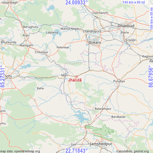
Jhalidā GPS coordinates[2]
23° 21' 55.62" North, 85° 58' 35.148" East
| Map corner | latitude | longitude |
|---|---|---|
| Upper-left | 24.00933°, | 85.27331° |
| Center: | 23.36545°, | 85.97643° |
| Lower-right: | 22.71843°, | 86.67956° |
| Map W x H: | 143.5×143.5 km | = 89.2×89.2mi |
| max Lat: | 34.9274° ⇑45.9% North |
| Jhalidā: | 23.36545° |
| min Lat: | ⇓54.1% South 8.09008° |
| min Long | Jhalidā | max Long |
| 68.82655° | 85.97643° | 96.81° |
| W 86.9%⇐ | ⇒13.1% E |
Elevation
Elevation of Jhalidā is 298 m = 978 ft, and this is 2.4 m = 8 ft above average elevation for this country.
| Max E: |
3681 m = 12077 ft | 33.5% |
| Jhalidā | 298 m 978 ft | |
| Avg. | 295.6 m = 970 ft | |
Min E: |
1 m = 3 ft | 66.5% |
See also: India elevation on elevation.city.
Geographical zone
Jhalidā is located in North Torrid zone (between Equator and Tropic of Cancer). Distance of this Northern Tropic circle is 7.9 km =4.9 mi to North.| Distance of | km | miles | from Jhalidā |
|---|---|---|---|
| North Pole | 7409.1 | 4603.8 | to North |
| Arctic Circle | 4803.2 | 2984.6 | to North |
| Tropic Cancer | 7.9 | 4.9 | to North |
| Equator | 2598 | 1614.3 | to South |


Nearby cities:
15 places around Jhalidā: (largest is in red/bold)
• Bagra
53.6 km =33.3 mi,  40°
40°
• Balarāmpur
39 km =24.2 mi,  139°
139°
• Bhojudih
56.3 km =35 mi,  57°
57°
• Bokāro
46.9 km =29.1 mi,  357°
357°
• Būndu
45.5 km =28.3 mi,  240°
240°
• Chāndil
46 km =28.6 mi,  170°
170°
• Chās
35.8 km =22.2 mi,  32°
32°
• Dugda
46.7 km =29 mi, 25°
• Gumia
50.4 km =31.3 mi,  342°
342°
• Malkera
56.1 km =34.9 mi, 34°
• Muri
11.7 km =7.3 mi,  272°
272°
• Puruliya
39.7 km =24.7 mi,  95°
95°
• Pāthardih
57.2 km =35.5 mi,  54°
54°
• Rāmgarh
54.9 km =34.1 mi,  302°
302°
• Sāruberā
50.4 km =31.3 mi,  2°
2°
Sources, notices
• [Note1] Compared only with cities in India existing in our database
• [Src1] Map data: © OpenStreetMap contributors (CC-BY-SA)
• [Src2] Other city data from geonames.org with taken over terms of usage.
• [Src3] Geographical zone / Annual Mean Temperature by Robert A. Rohde @ Wikipedia
