Kāgal geodata
Kāgal (Maharashtra) is a populated place; located in India in Asia/Kolkata (GMT+5.5) time zone. With population of 25,479 people, there are 1669 cities with bigger population in this country. Compared to other cities in India, 76.1% of cities are located further ↑North; 87.9% of cities are located further →East and 86.2% of cities have lower elevation than Kāgal. Note1


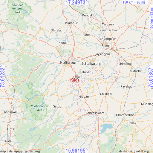
Kāgal GPS coordinates[2]
16° 34' 37.272" North, 74° 18' 55.584" East
| Map corner | latitude | longitude |
|---|---|---|
| Upper-left | 17.24973°, | 73.61232° |
| Center: | 16.57702°, | 74.31544° |
| Lower-right: | 15.90195°, | 75.01857° |
| Map W x H: | 149.9×149.9 km | = 93.1×93.1mi |
| max Lat: | 34.9274° ⇑76.1% North |
| Kāgal: | 16.57702° |
| min Lat: | ⇓23.9% South 8.09008° |
| min Long | Kāgal | max Long |
| 68.82655° | 74.31544° | 96.81° |
| W 12.1%⇐ | ⇒87.9% E |
Elevation
Elevation of Kāgal is 565 m = 1854 ft, and this is 269.4 m = 884 ft above average elevation for this country.
| Max E: |
3681 m = 12077 ft | 13.8% |
| Kāgal | 565 m 1854 ft | |
| Avg. | 295.6 m = 970 ft | |
Min E: |
1 m = 3 ft | 86.2% |
See also: India elevation on elevation.city.
Geographical zone
Kāgal is located in North Torrid zone (between Equator and Tropic of Cancer). Distance of this Northern Tropic circle is 762.7 km =473.9 mi to North.| Distance of | km | miles | from Kāgal |
|---|---|---|---|
| North Pole | 8163.9 | 5072.8 | to North |
| Arctic Circle | 5558 | 3453.6 | to North |
| Tropic Cancer | 762.7 | 473.9 | to North |
| Equator | 1843.2 | 1145.3 | to South |


Nearby cities:
15 places around Kāgal: (largest is in red/bold)
• Ashta
42.6 km =26.5 mi,  13°
13°
• Chikodi
33.2 km =20.6 mi,  119°
119°
• Gadhinglaj
39.5 km =24.5 mi,  174°
174°
• Ichalkaranji
20 km =12.4 mi,  50°
50°
• Jaisingpur
33.7 km =20.9 mi, 48°
• Kodoli
35.8 km =22.2 mi,  338°
338°
• Kolhāpur
15.9 km =9.9 mi,  325°
325°
• Kurandvād
31.4 km =19.5 mi,  67°
67°
• Murgūd
24.1 km =15 mi,  213°
213°
• Nipāni
21.1 km =13.1 mi,  160°
160°
• Panhāla
34.1 km =21.2 mi,  320°
320°
• Sadalgi
23.2 km =14.4 mi,  95°
95°
• Sankeshwar
39.8 km =24.7 mi,  153°
153°
• Shiraguppi
42.2 km =26.2 mi,  83°
83°
• Sāngli
40.7 km =25.3 mi,  40°
40°
Sources, notices
• [Note1] Compared only with cities in India existing in our database
• [Src1] Map data: © OpenStreetMap contributors (CC-BY-SA)
• [Src2] Other city data from geonames.org with taken over terms of usage.
• [Src3] Geographical zone / Annual Mean Temperature by Robert A. Rohde @ Wikipedia
