Shiraguppi geodata
Shiraguppi (Maharashtra) is a farm village; located in India in Asia/Kolkata (GMT+5.5) time zone. With population of 25,000 people, there are 1701 cities with bigger population in this country. Compared to other cities in India, 76% of cities are located further ↑North; 85.2% of cities are located further →East and 84.4% of cities have lower elevation than Shiraguppi. Note1


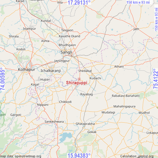
Shiraguppi GPS coordinates[2]
16° 37' 7.5" North, 74° 42' 32.652" East
| Map corner | latitude | longitude |
|---|---|---|
| Upper-left | 17.29131°, | 74.00595° |
| Center: | 16.61875°, | 74.70907° |
| Lower-right: | 15.94383°, | 75.4122° |
| Map W x H: | 149.8×149.8 km | = 93.1×93.1mi |
| max Lat: | 34.9274° ⇑76% North |
| Shiraguppi: | 16.61875° |
| min Lat: | ⇓24% South 8.09008° |
| min Long | Shiraguppi | max Long |
| 68.82655° | 74.70907° | 96.81° |
| W 14.8%⇐ | ⇒85.2% E |
Elevation
Elevation of Shiraguppi is 540 m = 1772 ft, and this is 244.4 m = 802 ft above average elevation for this country.
| Max E: |
3681 m = 12077 ft | 15.6% |
| Shiraguppi | 540 m 1772 ft | |
| Avg. | 295.6 m = 970 ft | |
Min E: |
1 m = 3 ft | 84.4% |
See also: India elevation on elevation.city.
Geographical zone
Shiraguppi is located in North Torrid zone (between Equator and Tropic of Cancer). Distance of this Northern Tropic circle is 758.1 km =471.1 mi to North.| Distance of | km | miles | from Shiraguppi |
|---|---|---|---|
| North Pole | 8159.2 | 5069.9 | to North |
| Arctic Circle | 5553.3 | 3450.7 | to North |
| Tropic Cancer | 758.1 | 471.1 | to North |
| Equator | 1847.8 | 1148.2 | to South |


Nearby cities:
15 places around Shiraguppi: (largest is in red/bold)
• Athni
39.7 km =24.7 mi,  72°
72°
• Bhudgaon
34.1 km =21.2 mi,  340°
340°
• Chikodi
24.9 km =15.5 mi,  211°
211°
• Hukeri
44.6 km =27.7 mi,  194°
194°
• Ichalkaranji
27.7 km =17.2 mi,  286°
286°
• Jaisingpur
24.1 km =15 mi,  316°
316°
• Kudachi
15.5 km =9.6 mi,  86°
86°
• Kurandvād
14.7 km =9.1 mi,  299°
299°
• Kāgal
42.2 km =26.2 mi,  263°
263°
• Nipāni
42.5 km =26.4 mi,  234°
234°
• Rabkavi
45.7 km =28.4 mi,  110°
110°
• Rāybāg
15.7 km =9.8 mi,  153°
153°
• Sadalgi
20 km =12.4 mi,  250°
250°
• Sāngli
30.4 km =18.9 mi,  329°
329°
• Terdāl
38.6 km =24 mi, 111°
Sources, notices
• [Note1] Compared only with cities in India existing in our database
• [Src1] Map data: © OpenStreetMap contributors (CC-BY-SA)
• [Src2] Other city data from geonames.org with taken over terms of usage.
• [Src3] Geographical zone / Annual Mean Temperature by Robert A. Rohde @ Wikipedia
