Kurandvād geodata
Kurandvād (Maharashtra) is a populated place; located in India in Asia/Kolkata (GMT+5.5) time zone. With population of 21,388 people, there are 1943 cities with bigger population in this country. Compared to other cities in India, 75.8% of cities are located further ↑North; 86.1% of cities are located further →East and 84.6% of cities have lower elevation than Kurandvād. Note1


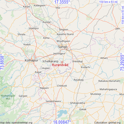
Kurandvād GPS coordinates[2]
16° 40' 59.412" North, 74° 35' 20.112" East
| Map corner | latitude | longitude |
|---|---|---|
| Upper-left | 17.3555°, | 73.8858° |
| Center: | 16.68317°, | 74.58892° |
| Lower-right: | 16.00847°, | 75.29205° |
| Map W x H: | 149.8×149.8 km | = 93.1×93.1mi |
| max Lat: | 34.9274° ⇑75.8% North |
| Kurandvād: | 16.68317° |
| min Lat: | ⇓24.2% South 8.09008° |
| min Long | Kurandvād | max Long |
| 68.82655° | 74.58892° | 96.81° |
| W 13.9%⇐ | ⇒86.1% E |
Elevation
Elevation of Kurandvād is 546 m = 1791 ft, and this is 250.4 m = 822 ft above average elevation for this country.
| Max E: |
3681 m = 12077 ft | 15.4% |
| Kurandvād | 546 m 1791 ft | |
| Avg. | 295.6 m = 970 ft | |
Min E: |
1 m = 3 ft | 84.6% |
See also: India elevation on elevation.city.
Geographical zone
Kurandvād is located in North Torrid zone (between Equator and Tropic of Cancer). Distance of this Northern Tropic circle is 750.9 km =466.6 mi to North.| Distance of | km | miles | from Kurandvād |
|---|---|---|---|
| North Pole | 8152.1 | 5065.5 | to North |
| Arctic Circle | 5546.2 | 3446.2 | to North |
| Tropic Cancer | 750.9 | 466.6 | to North |
| Equator | 1855 | 1152.6 | to South |


Nearby cities:
15 places around Kurandvād: (largest is in red/bold)
• Ashta
35.2 km =21.9 mi,  327°
327°
• Bhudgaon
25 km =15.5 mi,  2°
2°
• Chikodi
28.3 km =17.6 mi,  180°
180°
• Ichalkaranji
13.7 km =8.5 mi,  273°
273°
• Jaisingpur
11 km =6.8 mi,  340°
340°
• Kodoli
47.5 km =29.5 mi,  296°
296°
• Kolhāpur
38.1 km =23.7 mi, 272°
• Kudachi
28.9 km =18 mi,  102°
102°
• Kāgal
31.4 km =19.5 mi,  247°
247°
• Nipāni
38.5 km =23.9 mi,  214°
214°
• Rāybāg
29 km =18 mi,  137°
137°
• Sadalgi
15.1 km =9.4 mi,  203°
203°
• Shiraguppi
14.7 km =9.1 mi,  119°
119°
• Sāngli
19.2 km =11.9 mi,  352°
352°
• Tāsgaon
39.4 km =24.5 mi, 1°
Sources, notices
• [Note1] Compared only with cities in India existing in our database
• [Src1] Map data: © OpenStreetMap contributors (CC-BY-SA)
• [Src2] Other city data from geonames.org with taken over terms of usage.
• [Src3] Geographical zone / Annual Mean Temperature by Robert A. Rohde @ Wikipedia
