Sankeshwar geodata
Sankeshwar (Karnataka) is a populated place; located in India in Asia/Kolkata (GMT+5.5) time zone. With population of 34,549 people, there are 1258 cities with bigger population in this country. Compared to other cities in India, 77.3% of cities are located further ↑North; 86.9% of cities are located further →East and 90% of cities have lower elevation than Sankeshwar. Note1


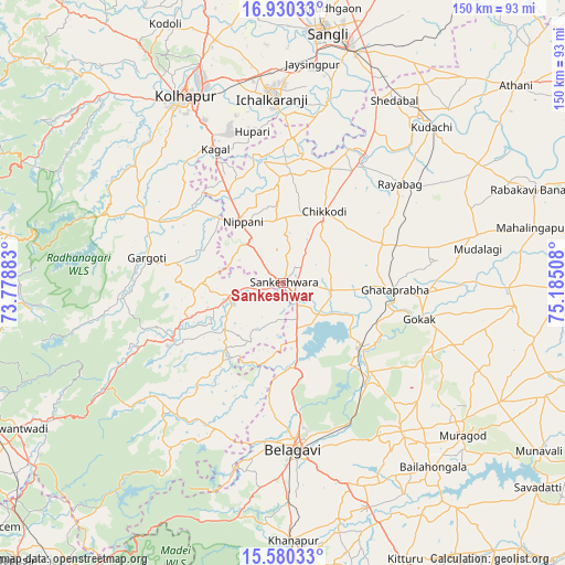
Sankeshwar GPS coordinates[2]
16° 15' 23.364" North, 74° 28' 55.02" East
| Map corner | latitude | longitude |
|---|---|---|
| Upper-left | 16.93033°, | 73.77883° |
| Center: | 16.25649°, | 74.48195° |
| Lower-right: | 15.58033°, | 75.18508° |
| Map W x H: | 150.1×150.1 km | = 93.3×93.3mi |
| max Lat: | 34.9274° ⇑77.3% North |
| Sankeshwar: | 16.25649° |
| min Lat: | ⇓22.7% South 8.09008° |
| min Long | Sankeshwar | max Long |
| 68.82655° | 74.48195° | 96.81° |
| W 13.1%⇐ | ⇒86.9% E |
Elevation
Elevation of Sankeshwar is 638 m = 2093 ft, and this is 342.4 m = 1123 ft above average elevation for this country.
| Max E: |
3681 m = 12077 ft | 10% |
| Sankeshwar | 638 m 2093 ft | |
| Avg. | 295.6 m = 970 ft | |
Min E: |
1 m = 3 ft | 90% |
See also: India elevation on elevation.city.
Geographical zone
Sankeshwar is located in North Torrid zone (between Equator and Tropic of Cancer). Distance of this Northern Tropic circle is 798.4 km =496.1 mi to North.| Distance of | km | miles | from Sankeshwar |
|---|---|---|---|
| North Pole | 8199.5 | 5094.9 | to North |
| Arctic Circle | 5593.6 | 3475.7 | to North |
| Tropic Cancer | 798.4 | 496.1 | to North |
| Equator | 1807.6 | 1123.2 | to South |


Nearby cities:
15 places around Sankeshwar: (largest is in red/bold)
• Ajra
32.9 km =20.4 mi,  241°
241°
• Belgaum
45 km =28 mi,  176°
176°
• Chikodi
22.2 km =13.8 mi,  30°
30°
• Gadhinglaj
14.6 km =9.1 mi,  255°
255°
• Gokak
37.8 km =23.5 mi,  104°
104°
• Hukeri
13.2 km =8.2 mi, 102°
• Ichalkaranji
48.4 km =30.1 mi,  357°
357°
• Konnūr
29.1 km =18.1 mi, 102°
• Kurandvād
48.8 km =30.3 mi,  13°
13°
• Kāgal
39.8 km =24.7 mi,  333°
333°
• Murgūd
34.7 km =21.6 mi,  296°
296°
• Nipāni
19.1 km =11.9 mi, 326°
• Rāybāg
40.7 km =25.3 mi,  49°
49°
• Sadalgi
34 km =21.1 mi, 9°
• Shiraguppi
47 km =29.2 mi, 31°
Sources, notices
• [Note1] Compared only with cities in India existing in our database
• [Src1] Map data: © OpenStreetMap contributors (CC-BY-SA)
• [Src2] Other city data from geonames.org with taken over terms of usage.
• [Src3] Geographical zone / Annual Mean Temperature by Robert A. Rohde @ Wikipedia
