Panhāla geodata
Panhāla (Maharashtra) is a populated place; located in India in Asia/Kolkata (GMT+5.5) time zone. With population of 3,634 people, there are 3389 cities with bigger population in this country. Compared to other cities in India, 75.4% of cities are located further ↑North; 88.8% of cities are located further →East and 95.8% of cities have lower elevation than Panhāla. Note1


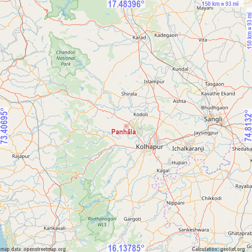
Panhāla GPS coordinates[2]
16° 48' 43.56" North, 74° 6' 36.252" East
| Map corner | latitude | longitude |
|---|---|---|
| Upper-left | 17.48396°, | 73.40695° |
| Center: | 16.8121°, | 74.11007° |
| Lower-right: | 16.13785°, | 74.8132° |
| Map W x H: | 149.7×149.7 km | = 93×93mi |
| max Lat: | 34.9274° ⇑75.4% North |
| Panhāla: | 16.8121° |
| min Lat: | ⇓24.6% South 8.09008° |
| min Long | Panhāla | max Long |
| 68.82655° | 74.11007° | 96.81° |
| W 11.2%⇐ | ⇒88.8% E |
Elevation
Elevation of Panhāla is 947 m = 3107 ft, and this is 651.4 m = 2137 ft above average elevation for this country.
| Max E: |
3681 m = 12077 ft | 4.2% |
| Panhāla | 947 m 3107 ft | |
| Avg. | 295.6 m = 970 ft | |
Min E: |
1 m = 3 ft | 95.8% |
See also: India elevation on elevation.city.
Geographical zone
Panhāla is located in North Torrid zone (between Equator and Tropic of Cancer). Distance of this Northern Tropic circle is 736.6 km =457.7 mi to North.| Distance of | km | miles | from Panhāla |
|---|---|---|---|
| North Pole | 8137.7 | 5056.5 | to North |
| Arctic Circle | 5531.8 | 3437.3 | to North |
| Tropic Cancer | 736.6 | 457.7 | to North |
| Equator | 1869.3 | 1161.5 | to South |


Nearby cities:
15 places around Panhāla: (largest is in red/bold)
• Ashta
35.3 km =21.9 mi,  64°
64°
• Bhudgaon
53.2 km =33.1 mi,  78°
78°
• Ichalkaranji
39.7 km =24.7 mi,  109°
109°
• Jaisingpur
47.4 km =29.5 mi,  94°
94°
• Karād
53.6 km =33.3 mi,  8°
8°
• Kodoli
11.2 km =7 mi,  50°
50°
• Kolhāpur
18.3 km =11.4 mi,  135°
135°
• Kurandvād
53 km =32.9 mi, 105°
• Kāgal
34.1 km =21.2 mi, 140°
• Malkapur
50.5 km =31.4 mi, 7°
• Malkāpur
22.2 km =13.8 mi,  302°
302°
• Murgūd
47.1 km =29.3 mi,  169°
169°
• Nipāni
54.4 km =33.8 mi,  147°
147°
• Sadalgi
53.1 km =33 mi,  122°
122°
• Sāngli
48.6 km =30.2 mi, 84°
Sources, notices
• [Note1] Compared only with cities in India existing in our database
• [Src1] Map data: © OpenStreetMap contributors (CC-BY-SA)
• [Src2] Other city data from geonames.org with taken over terms of usage.
• [Src3] Geographical zone / Annual Mean Temperature by Robert A. Rohde @ Wikipedia
