Ghātāl geodata
Ghātāl (West Bengal) is a populated place; located in India in Asia/Kolkata (GMT+5.5) time zone. With population of 54,658 people, there are 813 cities with bigger population in this country. Compared to other cities in India, 51.5% of cities are located further ↑North; 90.6% of cities are located further ←West and 94.3% of cities have higher elevation than Ghātāl. Note1


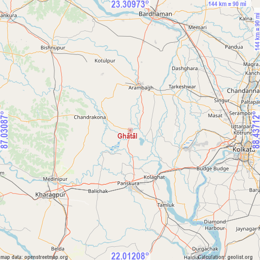
Ghātāl GPS coordinates[2]
22° 39' 44.784" North, 87° 44' 2.364" East
| Map corner | latitude | longitude |
|---|---|---|
| Upper-left | 23.30973°, | 87.03087° |
| Center: | 22.66244°, | 87.73399° |
| Lower-right: | 22.01208°, | 88.43712° |
| Map W x H: | 144.3×144.3 km | = 89.7×89.7mi |
| max Lat: | 34.9274° ⇑51.5% North |
| Ghātāl: | 22.66244° |
| min Lat: | ⇓48.5% South 8.09008° |
| min Long | Ghātāl | max Long |
| 68.82655° | 87.73399° | 96.81° |
| W 90.6%⇐ | ⇒9.4% E |
Elevation
Elevation of Ghātāl is 12 m = 39 ft, and this is 283.6 m = 930 ft below average elevation for this country.
| Max E: |
3681 m = 12077 ft | 94.3% |
| Avg. | 295.6 m = 970 ft | |
| Ghātāl | 12 m = 39 ft | |
Min E: |
1 m = 3 ft | 5.7% |
See also: Ghātāl elevation on elevation.city.
Geographical zone
Ghātāl is located in North Torrid zone (between Equator and Tropic of Cancer). Distance of this Northern Tropic circle is 86.1 km =53.5 mi to North.| Distance of | km | miles | from Ghātāl |
|---|---|---|---|
| North Pole | 7487.2 | 4652.3 | to North |
| Arctic Circle | 4881.3 | 3033.1 | to North |
| Tropic Cancer | 86.1 | 53.5 | to North |
| Equator | 2519.8 | 1565.7 | to South |


Nearby cities:
15 places around Ghātāl: (largest is in red/bold)
• Arāmbāgh
25.1 km =15.6 mi,  11°
11°
• Bhandārdaha
47.3 km =29.4 mi,  96°
96°
• Bāli Chak
38 km =23.6 mi,  209°
209°
• Chandrakona
23.6 km =14.7 mi,  289°
289°
• Dhulagari
45.7 km =28.4 mi, 101°
• Gobindapur
37.5 km =23.3 mi, 101°
• Kharar
8.8 km =5.5 mi,  319°
319°
• Pānchla
43.8 km =27.2 mi,  108°
108°
• Rāmjībanpur
22.5 km =14 mi,  325°
325°
• Srirāmpur
43.2 km =26.8 mi,  42°
42°
• Sāhāpur
47 km =29.2 mi, 109°
• Tamlūk
44.8 km =27.8 mi,  153°
153°
• Tarakeswar
37.9 km =23.5 mi,  49°
49°
• Āmlāgora
45.7 km =28.4 mi,  296°
296°
• Āmta
29.7 km =18.5 mi, 107°
Sources, notices
• [Note1] Compared only with cities in India existing in our database
• [Src1] Map data: © OpenStreetMap contributors (CC-BY-SA)
• [Src2] Other city data from geonames.org with taken over terms of usage.
• [Src3] Geographical zone / Annual Mean Temperature by Robert A. Rohde @ Wikipedia
