Arāmbāgh geodata
Arāmbāgh (West Bengal) is a populated place; located in India in Asia/Kolkata (GMT+5.5) time zone. With population of 60,639 people, there are 722 cities with bigger population in this country. Compared to other cities in India, 50.7% of cities are located further ↓South; 90.7% of cities are located further ←West and 87.6% of cities have higher elevation than Arāmbāgh. Note1


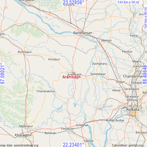
Arāmbāgh GPS coordinates[2]
22° 52' 59.988" North, 87° 46' 59.988" East
| Map corner | latitude | longitude |
|---|---|---|
| Upper-left | 23.52956°, | 87.08021° |
| Center: | 22.88333°, | 87.78333° |
| Lower-right: | 22.23401°, | 88.48646° |
| Map W x H: | 144.1×144.1 km | = 89.5×89.5mi |
| max Lat: | 34.9274° ⇑49.3% North |
| Arāmbāgh: | 22.88333° |
| min Lat: | ⇓50.7% South 8.09008° |
| min Long | Arāmbāgh | max Long |
| 68.82655° | 87.78333° | 96.81° |
| W 90.7%⇐ | ⇒9.3% E |
Elevation
Elevation of Arāmbāgh is 23 m = 75 ft, and this is 272.6 m = 894 ft below average elevation for this country.
| Max E: |
3681 m = 12077 ft | 87.6% |
| Avg. | 295.6 m = 970 ft | |
| Arāmbāgh | 23 m = 75 ft | |
Min E: |
1 m = 3 ft | 12.4% |
See also: Arāmbāgh elevation on elevation.city.
Geographical zone
Arāmbāgh is located in North Torrid zone (between Equator and Tropic of Cancer). Distance of this Northern Tropic circle is 61.5 km =38.2 mi to North.| Distance of | km | miles | from Arāmbāgh |
|---|---|---|---|
| North Pole | 7462.7 | 4637.1 | to North |
| Arctic Circle | 4856.8 | 3017.9 | to North |
| Tropic Cancer | 61.5 | 38.2 | to North |
| Equator | 2544.4 | 1581 | to South |


Nearby cities:
15 places around Arāmbāgh: (largest is in red/bold)
• Barddhamān
42.1 km =26.2 mi,  10°
10°
• Bāgnān
36.8 km =22.9 mi,  81°
81°
• Chandrakona
32 km =19.9 mi,  238°
238°
• Ghātāl
25.1 km =15.6 mi,  191°
191°
• Gobindapur
45.2 km =28.1 mi,  135°
135°
• Haripur
46.3 km =28.8 mi, 82°
• Kharar
20.9 km =13 mi,  211°
211°
• Memāri
45.8 km =28.5 mi,  44°
44°
• Pātrasāer
43.3 km =26.9 mi,  323°
323°
• Rāmjībanpur
18.9 km =11.7 mi,  251°
251°
• Singur
46.4 km =28.8 mi,  100°
100°
• Srirāmpur
25.3 km =15.7 mi,  73°
73°
• Tarakeswar
23.6 km =14.7 mi,  89°
89°
• Āmlāgora
46.1 km =28.6 mi,  264°
264°
• Āmta
40.7 km =25.3 mi,  145°
145°
Sources, notices
• [Note1] Compared only with cities in India existing in our database
• [Src1] Map data: © OpenStreetMap contributors (CC-BY-SA)
• [Src2] Other city data from geonames.org with taken over terms of usage.
• [Src3] Geographical zone / Annual Mean Temperature by Robert A. Rohde @ Wikipedia
