Chandrakona geodata
Chandrakona (West Bengal) is a populated place; located in India in Asia/Kolkata (GMT+5.5) time zone. With population of 21,855 people, there are 1909 cities with bigger population in this country. Compared to other cities in India, 50.5% of cities are located further ↑North; 90.2% of cities are located further ←West and 82.3% of cities have higher elevation than Chandrakona. Note1


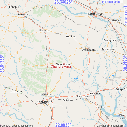
Chandrakona GPS coordinates[2]
22° 43' 59.988" North, 87° 31' 0.012" East
| Map corner | latitude | longitude |
|---|---|---|
| Upper-left | 23.38028°, | 86.81355° |
| Center: | 22.73333°, | 87.51667° |
| Lower-right: | 22.0833°, | 88.2198° |
| Map W x H: | 144.2×144.2 km | = 89.6×89.6mi |
| max Lat: | 34.9274° ⇑50.5% North |
| Chandrakona: | 22.73333° |
| min Lat: | ⇓49.5% South 8.09008° |
| min Long | Chandrakona | max Long |
| 68.82655° | 87.51667° | 96.81° |
| W 90.2%⇐ | ⇒9.8% E |
Elevation
Elevation of Chandrakona is 39 m = 128 ft, and this is 256.6 m = 842 ft below average elevation for this country.
| Max E: |
3681 m = 12077 ft | 82.3% |
| Avg. | 295.6 m = 970 ft | |
| Chandrakona | 39 m = 128 ft | |
Min E: |
1 m = 3 ft | 17.7% |
See also: India elevation on elevation.city.
Geographical zone
Chandrakona is located in North Torrid zone (between Equator and Tropic of Cancer). Distance of this Northern Tropic circle is 78.2 km =48.6 mi to North.| Distance of | km | miles | from Chandrakona |
|---|---|---|---|
| North Pole | 7479.4 | 4647.5 | to North |
| Arctic Circle | 4873.5 | 3028.3 | to North |
| Tropic Cancer | 78.2 | 48.6 | to North |
| Equator | 2527.7 | 1570.6 | to South |


Nearby cities:
15 places around Chandrakona: (largest is in red/bold)
• Arāmbāgh
32 km =19.9 mi,  58°
58°
• Bishnupur
42.9 km =26.7 mi,  331°
331°
• Bāli Chak
41.1 km =25.5 mi,  174°
174°
• Ghātāl
23.6 km =14.7 mi,  109°
109°
• Gobindapur
61 km =37.9 mi,  104°
104°
• Kalaīkunda
53 km =32.9 mi,  214°
214°
• Kharagpur
48 km =29.8 mi,  204°
204°
• Kharar
16.6 km =10.3 mi,  94°
94°
• Medinīpur
40 km =24.9 mi, 209°
• Pātrasāer
51.6 km =32.1 mi,  1°
1°
• Rāmjībanpur
14.2 km =8.8 mi,  41°
41°
• Srirāmpur
56.8 km =35.3 mi,  65°
65°
• Tarakeswar
53.7 km =33.4 mi, 71°
• Āmlāgora
22.4 km =13.9 mi,  304°
304°
• Āmta
53.3 km =33.1 mi, 108°
Sources, notices
• [Note1] Compared only with cities in India existing in our database
• [Src1] Map data: © OpenStreetMap contributors (CC-BY-SA)
• [Src2] Other city data from geonames.org with taken over terms of usage.
• [Src3] Geographical zone / Annual Mean Temperature by Robert A. Rohde @ Wikipedia
