Kharar geodata
Kharar (West Bengal) is a populated place; located in India in Asia/Kolkata (GMT+5.5) time zone. With population of 12,049 people, there are 2734 cities with bigger population in this country. Compared to other cities in India, 50.7% of cities are located further ↑North; 90.5% of cities are located further ←West and 90.4% of cities have higher elevation than Kharar. Note1


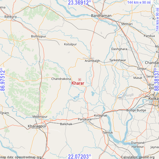
Kharar GPS coordinates[2]
22° 43' 19.596" North, 87° 40' 41.664" East
| Map corner | latitude | longitude |
|---|---|---|
| Upper-left | 23.36912°, | 86.97512° |
| Center: | 22.72211°, | 87.67824° |
| Lower-right: | 22.07203°, | 88.38137° |
| Map W x H: | 144.2×144.2 km | = 89.6×89.6mi |
| max Lat: | 34.9274° ⇑50.7% North |
| Kharar: | 22.72211° |
| min Lat: | ⇓49.3% South 8.09008° |
| min Long | Kharar | max Long |
| 68.82655° | 87.67824° | 96.81° |
| W 90.5%⇐ | ⇒9.5% E |
Elevation
Elevation of Kharar is 17 m = 56 ft, and this is 278.6 m = 914 ft below average elevation for this country.
| Max E: |
3681 m = 12077 ft | 90.4% |
| Avg. | 295.6 m = 970 ft | |
| Kharar | 17 m = 56 ft | |
Min E: |
1 m = 3 ft | 9.6% |
See also: India elevation on elevation.city.
Geographical zone
Kharar is located in North Torrid zone (between Equator and Tropic of Cancer). Distance of this Northern Tropic circle is 79.5 km =49.4 mi to North.| Distance of | km | miles | from Kharar |
|---|---|---|---|
| North Pole | 7480.6 | 4648.2 | to North |
| Arctic Circle | 4874.7 | 3029 | to North |
| Tropic Cancer | 79.5 | 49.4 | to North |
| Equator | 2526.5 | 1569.9 | to South |


Nearby cities:
15 places around Kharar: (largest is in red/bold)
• Arāmbāgh
20.9 km =13 mi,  31°
31°
• Bāgnān
52.7 km =32.7 mi,  63°
63°
• Bāli Chak
41.8 km =26 mi,  197°
197°
• Chandrakona
16.6 km =10.3 mi,  274°
274°
• Dhulagari
52.9 km =32.9 mi,  107°
107°
• Ghātāl
8.8 km =5.5 mi,  139°
139°
• Gobindapur
44.8 km =27.8 mi, 108°
• Medinīpur
49.5 km =30.8 mi,  227°
227°
• Pānchla
51.5 km =32 mi, 113°
• Rāmjībanpur
13.8 km =8.6 mi,  328°
328°
• Srirāmpur
43.1 km =26.8 mi,  54°
54°
• Tamlūk
53.3 km =33.1 mi,  151°
151°
• Tarakeswar
38.9 km =24.2 mi, 62°
• Āmlāgora
37.7 km =23.4 mi,  291°
291°
• Āmta
37.4 km =23.2 mi, 114°
Sources, notices
• [Note1] Compared only with cities in India existing in our database
• [Src1] Map data: © OpenStreetMap contributors (CC-BY-SA)
• [Src2] Other city data from geonames.org with taken over terms of usage.
• [Src3] Geographical zone / Annual Mean Temperature by Robert A. Rohde @ Wikipedia
