Canning geodata
Canning (West Bengal) is a populated place; located in India in Asia/Kolkata (GMT+5.5) time zone. With population of 42,132 people, there are 1049 cities with bigger population in this country. Compared to other cities in India, 54.3% of cities are located further ↑North; 94.8% of cities are located further ←West and 99% of cities have higher elevation than Canning. Note1


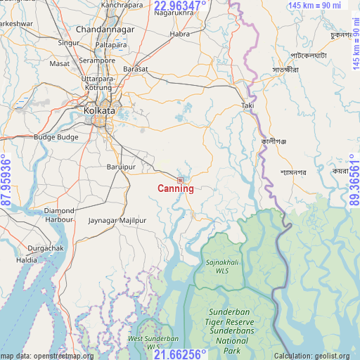
Canning GPS coordinates[2]
22° 18' 52.308" North, 88° 39' 44.928" East
| Map corner | latitude | longitude |
|---|---|---|
| Upper-left | 22.96347°, | 87.95936° |
| Center: | 22.31453°, | 88.66248° |
| Lower-right: | 21.66256°, | 89.36561° |
| Map W x H: | 144.6×144.7 km | = 89.9×89.9mi |
| max Lat: | 34.9274° ⇑54.3% North |
| Canning: | 22.31453° |
| min Lat: | ⇓45.7% South 8.09008° |
| min Long | Canning | max Long |
| 68.82655° | 88.66248° | 96.81° |
| W 94.8%⇐ | ⇒5.2% E |
Elevation
Elevation of Canning is 7 m = 23 ft, and this is 288.6 m = 947 ft below average elevation for this country.
| Max E: |
3681 m = 12077 ft | 99% |
| Avg. | 295.6 m = 970 ft | |
| Canning | 7 m = 23 ft | |
Min E: |
1 m = 3 ft | 1% |
See also: Canning elevation on elevation.city.
Geographical zone
Canning is located in North Torrid zone (between Equator and Tropic of Cancer). Distance of this Northern Tropic circle is 124.8 km =77.5 mi to North.| Distance of | km | miles | from Canning |
|---|---|---|---|
| North Pole | 7525.9 | 4676.4 | to North |
| Arctic Circle | 4920 | 3057.1 | to North |
| Tropic Cancer | 124.8 | 77.5 | to North |
| Equator | 2481.1 | 1541.7 | to South |


Nearby cities:
15 places around Canning: (largest is in red/bold)
• Amtala
40 km =24.9 mi,  278°
278°
• Balarāmpur
37.6 km =23.4 mi,  273°
273°
• Bara Bazar
42.6 km =26.5 mi,  311°
311°
• Bishnupur
40.6 km =25.2 mi, 279°
• Bāruipur
23.4 km =14.5 mi, 280°
• Bārāsat
23.9 km =14.9 mi,  245°
245°
• Chāmpāhāti
19.9 km =12.4 mi,  298°
298°
• Gopālpur
35 km =21.7 mi,  15°
15°
• Gosāba
21.8 km =13.5 mi,  139°
139°
• Jaynagar-Majilpur
29.5 km =18.3 mi,  238°
238°
• Kolkata
41.3 km =25.7 mi, 311°
• Nabagrām
16 km =9.9 mi,  259°
259°
• Raypur
19 km =11.8 mi, 304°
• Serpur
36.5 km =22.7 mi, 271°
• Tāki
41.2 km =25.6 mi,  42°
42°
Sources, notices
• [Note1] Compared only with cities in India existing in our database
• [Src1] Map data: © OpenStreetMap contributors (CC-BY-SA)
• [Src2] Other city data from geonames.org with taken over terms of usage.
• [Src3] Geographical zone / Annual Mean Temperature by Robert A. Rohde @ Wikipedia
