Gopālpur geodata
Gopālpur (West Bengal) is a populated place; located in India in Asia/Kolkata (GMT+5.5) time zone. With population of 6,890 people, there are 3223 cities with bigger population in this country. Compared to other cities in India, 51.9% of cities are located further ↑North; 94.8% of cities are located further ←West and 92.8% of cities have higher elevation than Gopālpur. Note1


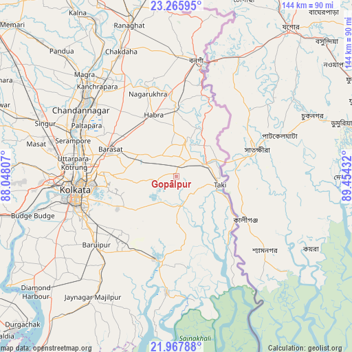
Gopālpur GPS coordinates[2]
22° 37' 6.42" North, 88° 45' 4.284" East
| Map corner | latitude | longitude |
|---|---|---|
| Upper-left | 23.26595°, | 88.04807° |
| Center: | 22.61845°, | 88.75119° |
| Lower-right: | 21.96788°, | 89.45432° |
| Map W x H: | 144.3×144.3 km | = 89.7×89.7mi |
| max Lat: | 34.9274° ⇑51.9% North |
| Gopālpur: | 22.61845° |
| min Lat: | ⇓48.1% South 8.09008° |
| min Long | Gopālpur | max Long |
| 68.82655° | 88.75119° | 96.81° |
| W 94.8%⇐ | ⇒5.2% E |
Elevation
Elevation of Gopālpur is 14 m = 46 ft, and this is 281.6 m = 924 ft below average elevation for this country.
| Max E: |
3681 m = 12077 ft | 92.8% |
| Avg. | 295.6 m = 970 ft | |
| Gopālpur | 14 m = 46 ft | |
Min E: |
1 m = 3 ft | 7.2% |
See also: India elevation on elevation.city.
Geographical zone
Gopālpur is located in North Torrid zone (between Equator and Tropic of Cancer). Distance of this Northern Tropic circle is 91 km =56.5 mi to North.| Distance of | km | miles | from Gopālpur |
|---|---|---|---|
| North Pole | 7492.1 | 4655.4 | to North |
| Arctic Circle | 4886.2 | 3036.1 | to North |
| Tropic Cancer | 91 | 56.5 | to North |
| Equator | 2514.9 | 1562.7 | to South |


Nearby cities:
15 places around Gopālpur: (largest is in red/bold)
• Ashoknagar Kalyangarh
29.7 km =18.5 mi,  336°
336°
• Badūria
14.5 km =9 mi,  14°
14°
• Bārāsat
29.9 km =18.6 mi,  292°
292°
• Canning
35 km =21.7 mi,  195°
195°
• Chāmpāhāti
36 km =22.4 mi,  227°
227°
• Dam Dam
33.7 km =20.9 mi,  272°
272°
• Garui
36.1 km =22.4 mi, 272°
• Gobārdānga
28.8 km =17.9 mi,  0°
0°
• Gurdaha
13 km =8.1 mi, 3°
• Hābra
26.7 km =16.6 mi, 338°
• Madhyamgram
32.3 km =20.1 mi,  284°
284°
• Nagarukhra
37.7 km =23.4 mi, 341°
• Raypur
33.9 km =21.1 mi, 227°
• Tāki
18.9 km =11.7 mi,  100°
100°
• Ula
23.2 km =14.4 mi,  299°
299°
Sources, notices
• [Note1] Compared only with cities in India existing in our database
• [Src1] Map data: © OpenStreetMap contributors (CC-BY-SA)
• [Src2] Other city data from geonames.org with taken over terms of usage.
• [Src3] Geographical zone / Annual Mean Temperature by Robert A. Rohde @ Wikipedia
