Khardah geodata
Khardah (West Bengal) is a populated place; located in India in Asia/Kolkata (GMT+5.5) time zone. With population of 128,346 people, there are 340 cities with bigger population in this country. Compared to other cities in India, 50.8% of cities are located further ↑North; 93.5% of cities are located further ←West and 96.4% of cities have higher elevation than Khardah. Note1


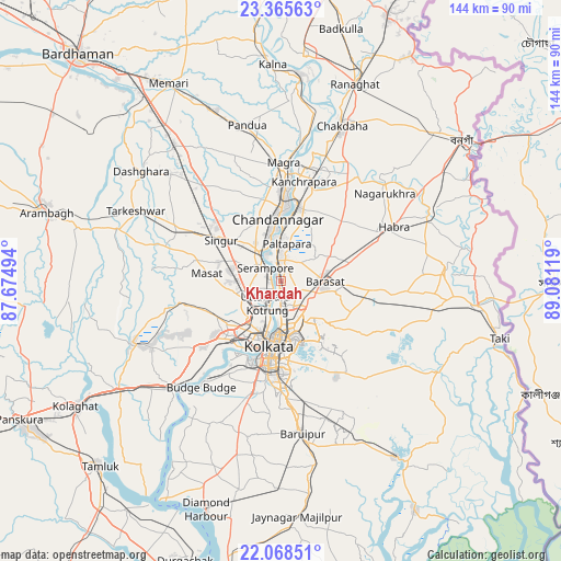
Khardah GPS coordinates[2]
22° 43' 6.996" North, 88° 22' 41.016" East
| Map corner | latitude | longitude |
|---|---|---|
| Upper-left | 23.36563°, | 87.67494° |
| Center: | 22.71861°, | 88.37806° |
| Lower-right: | 22.06851°, | 89.08119° |
| Map W x H: | 144.2×144.2 km | = 89.6×89.6mi |
| max Lat: | 34.9274° ⇑50.8% North |
| Khardah: | 22.71861° |
| min Lat: | ⇓49.2% South 8.09008° |
| min Long | Khardah | max Long |
| 68.82655° | 88.37806° | 96.81° |
| W 93.5%⇐ | ⇒6.5% E |
Elevation
Elevation of Khardah is 10 m = 33 ft, and this is 285.6 m = 937 ft below average elevation for this country.
| Max E: |
3681 m = 12077 ft | 96.4% |
| Avg. | 295.6 m = 970 ft | |
| Khardah | 10 m = 33 ft | |
Min E: |
1 m = 3 ft | 3.6% |
See also: Khardah elevation on elevation.city.
Geographical zone
Khardah is located in North Torrid zone (between Equator and Tropic of Cancer). Distance of this Northern Tropic circle is 79.8 km =49.6 mi to North.| Distance of | km | miles | from Khardah |
|---|---|---|---|
| North Pole | 7481 | 4648.5 | to North |
| Arctic Circle | 4875.1 | 3029.2 | to North |
| Tropic Cancer | 79.8 | 49.6 | to North |
| Equator | 2526.1 | 1569.6 | to South |


Nearby cities:
15 places around Khardah: (largest is in red/bold)
• Baidyabāti
9.1 km =5.7 mi,  324°
324°
• Baranagar
8.6 km =5.3 mi,  180°
180°
• Bāli
8.7 km =5.4 mi,  205°
205°
• Bārākpur
5.5 km =3.4 mi,  344°
344°
• Chakapara
10.1 km =6.3 mi,  197°
197°
• Dam Dam
10.5 km =6.5 mi,  154°
154°
• Garui
9.7 km =6 mi,  166°
166°
• Konnagar
3.8 km =2.4 mi,  246°
246°
• Kāmārhāti
5.3 km =3.3 mi, 183°
• Madhyamgram
7.7 km =4.8 mi,  114°
114°
• Pānihāti
3.1 km =1.9 mi,  187°
187°
• Rishra
3.4 km =2.1 mi,  280°
280°
• Shrīrāmpur
5.3 km =3.3 mi, 315°
• Sodpur
2.1 km =1.3 mi,  138°
138°
• Titāgarh
2.7 km =1.7 mi,  349°
349°
Sources, notices
• [Note1] Compared only with cities in India existing in our database
• [Src1] Map data: © OpenStreetMap contributors (CC-BY-SA)
• [Src2] Other city data from geonames.org with taken over terms of usage.
• [Src3] Geographical zone / Annual Mean Temperature by Robert A. Rohde @ Wikipedia
