Rishra geodata
Rishra (West Bengal) is a populated place; located in India in Asia/Kolkata (GMT+5.5) time zone. With population of 117,014 people, there are 379 cities with bigger population in this country. Compared to other cities in India, 50.7% of cities are located further ↑North; 93.1% of cities are located further ←West and 95.4% of cities have higher elevation than Rishra. Note1


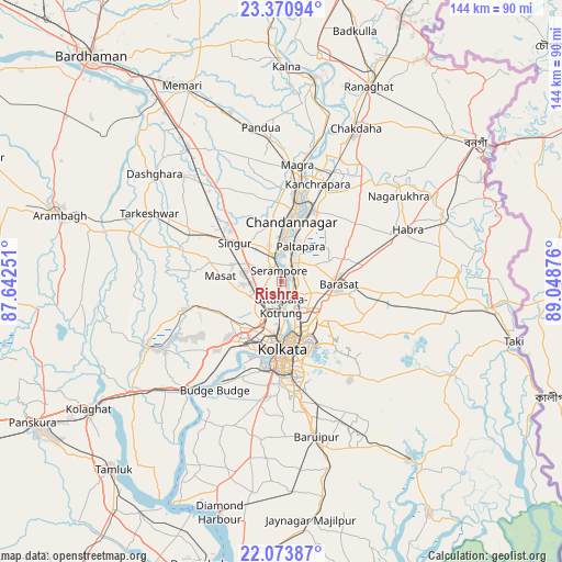
Rishra GPS coordinates[2]
22° 43' 26.184" North, 88° 20' 44.268" East
| Map corner | latitude | longitude |
|---|---|---|
| Upper-left | 23.37094°, | 87.64251° |
| Center: | 22.72394°, | 88.34563° |
| Lower-right: | 22.07387°, | 89.04876° |
| Map W x H: | 144.2×144.2 km | = 89.6×89.6mi |
| max Lat: | 34.9274° ⇑50.7% North |
| Rishra: | 22.72394° |
| min Lat: | ⇓49.3% South 8.09008° |
| min Long | Rishra | max Long |
| 68.82655° | 88.34563° | 96.81° |
| W 93.1%⇐ | ⇒6.9% E |
Elevation
Elevation of Rishra is 11 m = 36 ft, and this is 284.6 m = 934 ft below average elevation for this country.
| Max E: |
3681 m = 12077 ft | 95.4% |
| Avg. | 295.6 m = 970 ft | |
| Rishra | 11 m = 36 ft | |
Min E: |
1 m = 3 ft | 4.6% |
See also: Rishra elevation on elevation.city.
Geographical zone
Rishra is located in North Torrid zone (between Equator and Tropic of Cancer). Distance of this Northern Tropic circle is 79.3 km =49.3 mi to North.| Distance of | km | miles | from Rishra |
|---|---|---|---|
| North Pole | 7480.4 | 4648.1 | to North |
| Arctic Circle | 4874.5 | 3028.9 | to North |
| Tropic Cancer | 79.3 | 49.3 | to North |
| Equator | 2526.7 | 1570 | to South |


Nearby cities:
15 places around Rishra: (largest is in red/bold)
• Baidyabāti
7.1 km =4.4 mi,  343°
343°
• Baranagar
9.7 km =6 mi,  160°
160°
• Begampur
9.1 km =5.7 mi,  274°
274°
• Bāli
8.4 km =5.2 mi,  183°
183°
• Bārākpur
5 km =3.1 mi,  21°
21°
• Chakapara
10.2 km =6.3 mi, 178°
• Khardah
3.4 km =2.1 mi,  100°
100°
• Konnagar
2.1 km =1.3 mi, 183°
• Krishnapur
9.8 km =6.1 mi,  232°
232°
• Kāmārhāti
6.6 km =4.1 mi,  153°
153°
• Madhyamgram
11 km =6.8 mi,  110°
110°
• Pānihāti
4.7 km =2.9 mi,  141°
141°
• Shrīrāmpur
3.2 km =2 mi,  353°
353°
• Sodpur
5.2 km =3.2 mi, 114°
• Titāgarh
3.5 km =2.2 mi,  53°
53°
Sources, notices
• [Note1] Compared only with cities in India existing in our database
• [Src1] Map data: © OpenStreetMap contributors (CC-BY-SA)
• [Src2] Other city data from geonames.org with taken over terms of usage.
• [Src3] Geographical zone / Annual Mean Temperature by Robert A. Rohde @ Wikipedia
