Bārākpur geodata
Bārākpur (West Bengal) is a populated place; located in India in Asia/Kolkata (GMT+5.5) time zone. With population of 148,174 people, there are 297 cities with bigger population in this country. Compared to other cities in India, 50.2% of cities are located further ↑North; 93.2% of cities are located further ←West and 94.3% of cities have higher elevation than Bārākpur. Note1


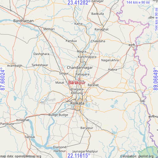
Bārākpur GPS coordinates[2]
22° 45' 57.672" North, 88° 21' 48.096" East
| Map corner | latitude | longitude |
|---|---|---|
| Upper-left | 23.41282°, | 87.66024° |
| Center: | 22.76602°, | 88.36336° |
| Lower-right: | 22.11615°, | 89.06649° |
| Map W x H: | 144.2×144.2 km | = 89.6×89.6mi |
| max Lat: | 34.9274° ⇑50.2% North |
| Bārākpur: | 22.76602° |
| min Lat: | ⇓49.8% South 8.09008° |
| min Long | Bārākpur | max Long |
| 68.82655° | 88.36336° | 96.81° |
| W 93.2%⇐ | ⇒6.8% E |
Elevation
Elevation of Bārākpur is 12 m = 39 ft, and this is 283.6 m = 930 ft below average elevation for this country.
| Max E: |
3681 m = 12077 ft | 94.3% |
| Avg. | 295.6 m = 970 ft | |
| Bārākpur | 12 m = 39 ft | |
Min E: |
1 m = 3 ft | 5.7% |
See also: Bārākpur elevation on elevation.city.
Geographical zone
Bārākpur is located in North Torrid zone (between Equator and Tropic of Cancer). Distance of this Northern Tropic circle is 74.6 km =46.4 mi to North.| Distance of | km | miles | from Bārākpur |
|---|---|---|---|
| North Pole | 7475.7 | 4645.2 | to North |
| Arctic Circle | 4869.8 | 3026 | to North |
| Tropic Cancer | 74.6 | 46.4 | to North |
| Equator | 2531.3 | 1572.9 | to South |


Nearby cities:
15 places around Bārākpur: (largest is in red/bold)
• Baidyabāti
4.4 km =2.7 mi,  298°
298°
• Begampur
11.5 km =7.1 mi,  250°
250°
• Bhadreswar
7 km =4.3 mi,  338°
338°
• Bhātpāra
11.8 km =7.3 mi,  19°
19°
• Chandannagar
10.7 km =6.6 mi,  2°
2°
• Khardah
5.5 km =3.4 mi,  164°
164°
• Konnagar
7 km =4.3 mi,  195°
195°
• Kāmārhāti
10.6 km =6.6 mi,  173°
173°
• Madhyamgram
12 km =7.5 mi,  135°
135°
• Pānihāti
8.4 km =5.2 mi, 172°
• Rishra
5 km =3.1 mi, 201°
• Shrīrāmpur
2.6 km =1.6 mi,  235°
235°
• Shyamnagar
7.5 km =4.7 mi, 2°
• Sodpur
7.5 km =4.7 mi, 157°
• Titāgarh
2.8 km =1.7 mi, 158°
Sources, notices
• [Note1] Compared only with cities in India existing in our database
• [Src1] Map data: © OpenStreetMap contributors (CC-BY-SA)
• [Src2] Other city data from geonames.org with taken over terms of usage.
• [Src3] Geographical zone / Annual Mean Temperature by Robert A. Rohde @ Wikipedia
