Baikunthpur geodata
Baikunthpur (Madhya Pradesh) is a populated place; located in India in Asia/Kolkata (GMT+5.5) time zone. With population of 10,179 people, there are 2926 cities with bigger population in this country. Compared to other cities in India, 61.9% of cities are located further ↓South; 74.4% of cities are located further ←West and 67.5% of cities have lower elevation than Baikunthpur. Note1


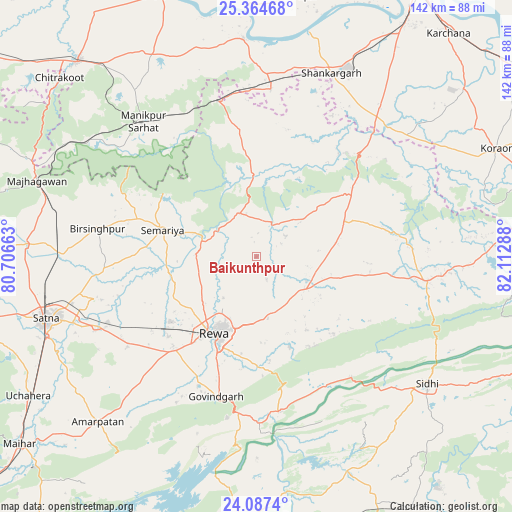
Baikunthpur GPS coordinates[2]
24° 43' 39.648" North, 81° 24' 35.1" East
| Map corner | latitude | longitude |
|---|---|---|
| Upper-left | 25.36468°, | 80.70663° |
| Center: | 24.72768°, | 81.40975° |
| Lower-right: | 24.0874°, | 82.11288° |
| Map W x H: | 142×142 km | = 88.2×88.2mi |
| max Lat: | 34.9274° ⇑38.1% North |
| Baikunthpur: | 24.72768° |
| min Lat: | ⇓61.9% South 8.09008° |
| min Long | Baikunthpur | max Long |
| 68.82655° | 81.40975° | 96.81° |
| W 74.4%⇐ | ⇒25.6% E |
Elevation
Elevation of Baikunthpur is 305 m = 1001 ft, and this is 9.4 m = 31 ft above average elevation for this country.
| Max E: |
3681 m = 12077 ft | 32.5% |
| Baikunthpur | 305 m 1001 ft | |
| Avg. | 295.6 m = 970 ft | |
Min E: |
1 m = 3 ft | 67.5% |
See also: India elevation on elevation.city.
Geographical zone
Baikunthpur is located in North temperate zone (between Tropic of Cancer and the Arctic Circle). Distance of this Northern Tropic circle is 143.5 km =89.2 mi to South.| Distance of | km | miles | from Baikunthpur |
|---|---|---|---|
| North Pole | 7257.6 | 4509.7 | to North |
| Arctic Circle | 4651.7 | 2890.4 | to North |
| Tropic Cancer | 143.5 | 89.2 | to South |
| Equator | 2749.5 | 1708.5 | to South |


Nearby cities:
15 places around Baikunthpur: (largest is in red/bold)
• Chorhat
42.5 km =26.4 mi,  141°
141°
• Govindgarh
40.5 km =25.2 mi,  196°
196°
• Gurh
26.6 km =16.5 mi,  159°
159°
• Kotwa
34.9 km =21.7 mi,  344°
344°
• Kotār
43.5 km =27 mi,  265°
265°
• Madhogarh
53.6 km =33.3 mi,  250°
250°
• Mangawān
15.3 km =9.5 mi,  115°
115°
• Mauganj
47.3 km =29.4 mi,  98°
98°
• Mānikpur
48.5 km =30.1 mi,  319°
319°
• Naīgarhi
37.8 km =23.5 mi,  79°
79°
• Rewa
24.7 km =15.3 mi,  208°
208°
• Simaria
27.1 km =16.8 mi,  286°
286°
• Sirmaur
12.9 km =8 mi, 339°
• Sohāgi
40.4 km =25.1 mi,  45°
45°
• Teonthar
36.7 km =22.8 mi,  39°
39°
Sources, notices
• [Note1] Compared only with cities in India existing in our database
• [Src1] Map data: © OpenStreetMap contributors (CC-BY-SA)
• [Src2] Other city data from geonames.org with taken over terms of usage.
• [Src3] Geographical zone / Annual Mean Temperature by Robert A. Rohde @ Wikipedia
