Ayyampettāi geodata
Ayyampettāi (Tamil Nadu) is a populated place; located in India in Asia/Kolkata (GMT+5.5) time zone. With population of 14,702 people, there are 2495 cities with bigger population in this country. Compared to other cities in India, 93.6% of cities are located further ↑North; 60.7% of cities are located further ←West and 83% of cities have higher elevation than Ayyampettāi. Note1


Ayyampettāi GPS coordinates[2]
10° 54' 5.076" North, 79° 10' 47.424" East
| Map corner | latitude | longitude |
|---|---|---|
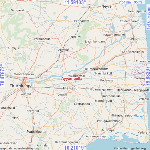
| Upper-left | 11.59103°, | 78.47672° |
| Center: | 10.90141°, | 79.17984° |
| Lower-right: | 10.21019°, | 79.88297° |
| Map W x H: | 153.5×153.5 km | = 95.4×95.4mi |
| max Lat: | 34.9274° ⇑93.6% North |
| Ayyampettāi: | 10.90141° |
| min Lat: | ⇓6.4% South 8.09008° |
| min Long | Ayyampettāi | max Long |
| 68.82655° | 79.17984° | 96.81° |
| W 60.7%⇐ | ⇒39.3% E |
Elevation
Elevation of Ayyampettāi is 37 m = 121 ft, and this is 258.6 m = 848 ft below average elevation for this country.
| Max E: |
3681 m = 12077 ft | 83% |
| Avg. | 295.6 m = 970 ft | |
| Ayyampettāi | 37 m = 121 ft | |
Min E: |
1 m = 3 ft | 17% |
See also: India elevation on elevation.city.
Geographical zone
Ayyampettāi is located in North Torrid zone (between Equator and Tropic of Cancer). Distance of Equator is 1212.1 km =753.2 mi to South.| Distance of | km | miles | from Ayyampettāi |
|---|---|---|---|
| North Pole | 8794.9 | 5464.9 | to North |
| Arctic Circle | 6189.1 | 3845.7 | to North |
| Tropic Cancer | 1393.8 | 866.1 | to North |
| Equator | 1212.1 | 753.2 | to South |


Nearby cities:
15 places around Ayyampettāi: (largest is in red/bold)
• Aduthurai
35.2 km =21.9 mi,  68°
68°
• Ammāpettai
19.3 km =12 mi,  127°
127°
• Ariyalūr
28.7 km =17.8 mi,  336°
336°
• Koradāchcheri
37 km =23 mi,  113°
113°
• Kumbakonam
24 km =14.9 mi, 73°
• Needamangalam
29.7 km =18.5 mi,  118°
118°
• Papanasam
10.3 km =6.4 mi, 74°
• Pullambādi
29.7 km =18.5 mi,  278°
278°
• Swāmimalai
17.5 km =10.9 mi, 69°
• Tanjore
13.7 km =8.5 mi,  199°
199°
• Thirukattupalli
25.2 km =15.7 mi,  255°
255°
• Thiruvaiyaru
8.5 km =5.3 mi, 256°
• Thiruvidaimaruthur
31.6 km =19.6 mi, 70°
• Valangaiman
23.3 km =14.5 mi,  93°
93°
• Vallam
24.1 km =15 mi,  213°
213°
Sources, notices
• [Note1] Compared only with cities in India existing in our database
• [Src1] Map data: © OpenStreetMap contributors (CC-BY-SA)
• [Src2] Other city data from geonames.org with taken over terms of usage.
• [Src3] Geographical zone / Annual Mean Temperature by Robert A. Rohde @ Wikipedia
