Pullambādi geodata
Pullambādi (Tamil Nadu) is a populated place; located in India in Asia/Kolkata (GMT+5.5) time zone. With population of 10,288 people, there are 2912 cities with bigger population in this country. Compared to other cities in India, 93.4% of cities are located further ↑North; 58.1% of cities are located further ←West and 75.7% of cities have higher elevation than Pullambādi. Note1


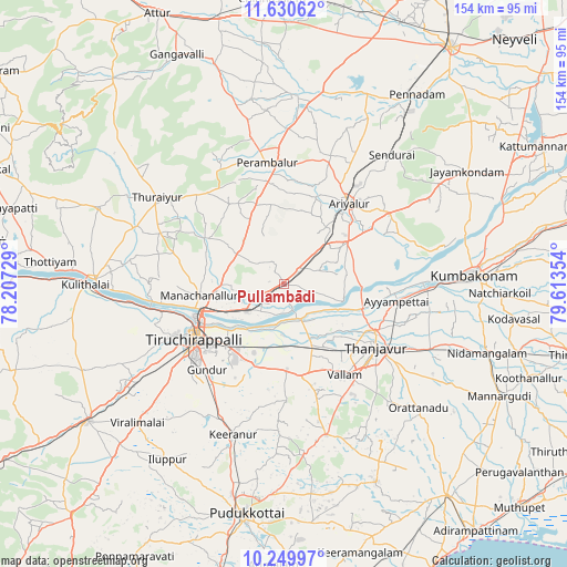
Pullambādi GPS coordinates[2]
10° 56' 27.96" North, 78° 54' 37.476" East
| Map corner | latitude | longitude |
|---|---|---|
| Upper-left | 11.63062°, | 78.20729° |
| Center: | 10.9411°, | 78.91041° |
| Lower-right: | 10.24997°, | 79.61354° |
| Map W x H: | 153.5×153.5 km | = 95.4×95.4mi |
| max Lat: | 34.9274° ⇑93.4% North |
| Pullambādi: | 10.9411° |
| min Lat: | ⇓6.6% South 8.09008° |
| min Long | Pullambādi | max Long |
| 68.82655° | 78.91041° | 96.81° |
| W 58.1%⇐ | ⇒41.9% E |
Elevation
Elevation of Pullambādi is 65 m = 213 ft, and this is 230.6 m = 757 ft below average elevation for this country.
| Max E: |
3681 m = 12077 ft | 75.7% |
| Avg. | 295.6 m = 970 ft | |
| Pullambādi | 65 m = 213 ft | |
Min E: |
1 m = 3 ft | 24.3% |
See also: India elevation on elevation.city.
Geographical zone
Pullambādi is located in North Torrid zone (between Equator and Tropic of Cancer). Distance of Equator is 1216.5 km =755.9 mi to South.| Distance of | km | miles | from Pullambādi |
|---|---|---|---|
| North Pole | 8790.5 | 5462.2 | to North |
| Arctic Circle | 6184.6 | 3842.9 | to North |
| Tropic Cancer | 1389.4 | 863.3 | to North |
| Equator | 1216.5 | 755.9 | to South |


Nearby cities:
15 places around Pullambādi: (largest is in red/bold)
• Ammāpettai
47.6 km =29.6 mi,  109°
109°
• Ariyalūr
28.4 km =17.6 mi,  39°
39°
• Ayyampettāi
29.7 km =18.5 mi,  98°
98°
• Kīranūr
43.4 km =27 mi,  198°
198°
• Lalgudi
12.4 km =7.7 mi,  233°
233°
• Papanasam
39.3 km =24.4 mi,  92°
92°
• Perambalur
32.6 km =20.3 mi,  354°
354°
• Puliyūr
35 km =21.7 mi,  192°
192°
• Swāmimalai
45.8 km =28.5 mi, 87°
• Tanjore
30.4 km =18.9 mi,  124°
124°
• Thirukattupalli
11.9 km =7.4 mi,  154°
154°
• Thiruvaiyaru
22 km =13.7 mi, 106°
• Tiruchirappalli
27.2 km =16.9 mi,  239°
239°
• Turaiyūr
41.2 km =25.6 mi,  304°
304°
• Vallam
29.5 km =18.3 mi, 146°
Sources, notices
• [Note1] Compared only with cities in India existing in our database
• [Src1] Map data: © OpenStreetMap contributors (CC-BY-SA)
• [Src2] Other city data from geonames.org with taken over terms of usage.
• [Src3] Geographical zone / Annual Mean Temperature by Robert A. Rohde @ Wikipedia
