Tanjore geodata
Tanjore (Tamil Nadu) is a populated place; located in India in Asia/Kolkata (GMT+5.5) time zone. With population of 219,571 people, there are 197 cities with bigger population in this country. Compared to other cities in India, 93.9% of cities are located further ↑North; 60.3% of cities are located further ←West and 77.5% of cities have higher elevation than Tanjore. Note1


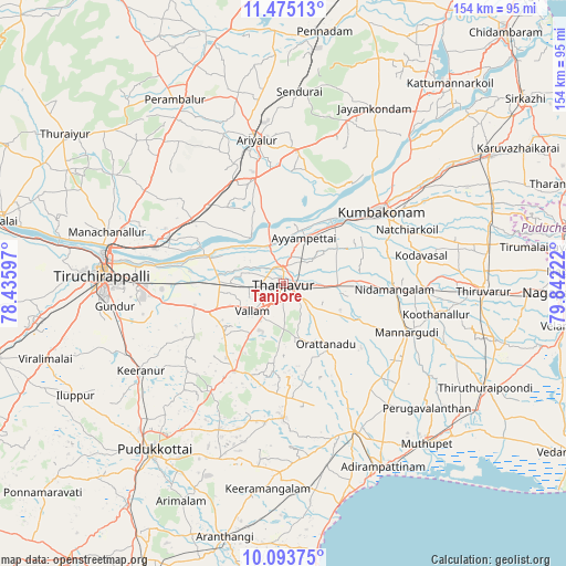
Tanjore GPS coordinates[2]
10° 47' 6.828" North, 79° 8' 20.724" East
| Map corner | latitude | longitude |
|---|---|---|
| Upper-left | 11.47513°, | 78.43597° |
| Center: | 10.78523°, | 79.13909° |
| Lower-right: | 10.09375°, | 79.84222° |
| Map W x H: | 153.6×153.6 km | = 95.4×95.4mi |
| max Lat: | 34.9274° ⇑93.9% North |
| Tanjore: | 10.78523° |
| min Lat: | ⇓6.1% South 8.09008° |
| min Long | Tanjore | max Long |
| 68.82655° | 79.13909° | 96.81° |
| W 60.3%⇐ | ⇒39.7% E |
Elevation
Elevation of Tanjore is 57 m = 187 ft, and this is 238.6 m = 783 ft below average elevation for this country.
| Max E: |
3681 m = 12077 ft | 77.5% |
| Avg. | 295.6 m = 970 ft | |
| Tanjore | 57 m = 187 ft | |
Min E: |
1 m = 3 ft | 22.5% |
See also: Tanjore elevation on elevation.city.
Geographical zone
Tanjore is located in North Torrid zone (between Equator and Tropic of Cancer). Distance of Equator is 1199.2 km =745.1 mi to South.| Distance of | km | miles | from Tanjore |
|---|---|---|---|
| North Pole | 8807.9 | 5473 | to North |
| Arctic Circle | 6202 | 3853.7 | to North |
| Tropic Cancer | 1406.7 | 874.1 | to North |
| Equator | 1199.2 | 745.1 | to South |


Nearby cities:
15 places around Tanjore: (largest is in red/bold)
• Ammāpettai
19.8 km =12.3 mi,  86°
86°
• Ayyampettāi
13.7 km =8.5 mi,  19°
19°
• Karambakkudi
36.3 km =22.6 mi,  179°
179°
• Kumbakonam
33.8 km =21 mi,  54°
54°
• Lalgudi
36.3 km =22.6 mi,  285°
285°
• Mannargudi
36.5 km =22.7 mi,  111°
111°
• Needamangalam
30.6 km =19 mi, 92°
• Papanasam
21.3 km =13.2 mi,  42°
42°
• Puliyūr
36.6 km =22.7 mi,  242°
242°
• Pullambādi
30.4 km =18.9 mi,  304°
304°
• Swāmimalai
28.3 km =17.6 mi, 47°
• Thirukattupalli
21 km =13 mi, 288°
• Thiruvaiyaru
11.7 km =7.3 mi,  340°
340°
• Valangaiman
30.1 km =18.7 mi,  67°
67°
• Vallam
11.3 km =7 mi,  230°
230°
Sources, notices
• [Note1] Compared only with cities in India existing in our database
• [Src1] Map data: © OpenStreetMap contributors (CC-BY-SA)
• [Src2] Other city data from geonames.org with taken over terms of usage.
• [Src3] Geographical zone / Annual Mean Temperature by Robert A. Rohde @ Wikipedia
