Vallam geodata
Vallam (Tamil Nadu) is a populated place; located in India in Asia/Kolkata (GMT+5.5) time zone. With population of 14,935 people, there are 2470 cities with bigger population in this country. Compared to other cities in India, 94.4% of cities are located further ↑North; 59.4% of cities are located further ←West and 72.9% of cities have higher elevation than Vallam. Note1


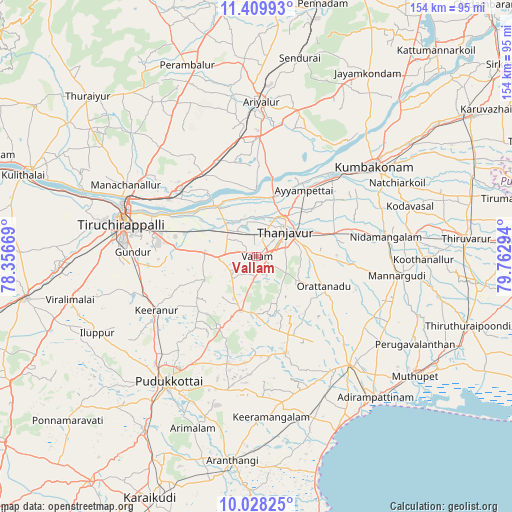
Vallam GPS coordinates[2]
10° 43' 11.568" North, 79° 3' 35.316" East
| Map corner | latitude | longitude |
|---|---|---|
| Upper-left | 11.40993°, | 78.35669° |
| Center: | 10.71988°, | 79.05981° |
| Lower-right: | 10.02825°, | 79.76294° |
| Map W x H: | 153.6×153.6 km | = 95.4×95.4mi |
| max Lat: | 34.9274° ⇑94.4% North |
| Vallam: | 10.71988° |
| min Lat: | ⇓5.6% South 8.09008° |
| min Long | Vallam | max Long |
| 68.82655° | 79.05981° | 96.81° |
| W 59.4%⇐ | ⇒40.6% E |
Elevation
Elevation of Vallam is 80 m = 262 ft, and this is 215.6 m = 707 ft below average elevation for this country.
| Max E: |
3681 m = 12077 ft | 72.9% |
| Avg. | 295.6 m = 970 ft | |
| Vallam | 80 m = 262 ft | |
Min E: |
1 m = 3 ft | 27.1% |
See also: India elevation on elevation.city.
Geographical zone
Vallam is located in North Torrid zone (between Equator and Tropic of Cancer). Distance of Equator is 1191.9 km =740.6 mi to South.| Distance of | km | miles | from Vallam |
|---|---|---|---|
| North Pole | 8815.1 | 5477.4 | to North |
| Arctic Circle | 6209.2 | 3858.2 | to North |
| Tropic Cancer | 1414 | 878.6 | to North |
| Equator | 1191.9 | 740.6 | to South |


Nearby cities:
15 places around Vallam: (largest is in red/bold)
• Ammāpettai
29.6 km =18.4 mi,  73°
73°
• Ayyampettāi
24.1 km =15 mi,  33°
33°
• Karambakkudi
30.4 km =18.9 mi,  163°
163°
• Kīranūr
34.2 km =21.3 mi,  240°
240°
• Lalgudi
31.4 km =19.5 mi,  303°
303°
• Needamangalam
39.7 km =24.7 mi,  81°
81°
• Papanasam
32.5 km =20.2 mi,  45°
45°
• Puliyūr
25.7 km =16 mi,  248°
248°
• Pullambādi
29.5 km =18.3 mi,  326°
326°
• Swāmimalai
39.5 km =24.5 mi, 48°
• Tanjore
11.3 km =7 mi, 50°
• Thirukattupalli
17.9 km =11.1 mi,  320°
320°
• Thiruvaiyaru
18.9 km =11.7 mi,  14°
14°
• Valangaiman
41 km =25.5 mi,  62°
62°
• Ālangudi
40.8 km =25.4 mi,  191°
191°
Sources, notices
• [Note1] Compared only with cities in India existing in our database
• [Src1] Map data: © OpenStreetMap contributors (CC-BY-SA)
• [Src2] Other city data from geonames.org with taken over terms of usage.
• [Src3] Geographical zone / Annual Mean Temperature by Robert A. Rohde @ Wikipedia
