Akhnūr geodata
Akhnūr (Jammu and Kashmir) is a populated place; located in India in Asia/Kolkata (GMT+5.5) time zone. With population of 12,802 people, there are 2673 cities with bigger population in this country. Compared to other cities in India, 98.8% of cities are located further ↓South; 85.1% of cities are located further →East and 68.6% of cities have lower elevation than Akhnūr. Note1


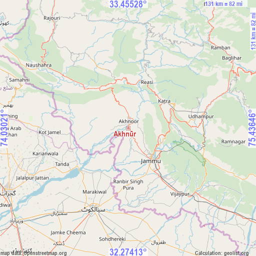
Akhnūr GPS coordinates[2]
32° 52' 0.012" North, 74° 43' 59.988" East
| Map corner | latitude | longitude |
|---|---|---|
| Upper-left | 33.45528°, | 74.03021° |
| Center: | 32.86667°, | 74.73333° |
| Lower-right: | 32.27413°, | 75.43646° |
| Map W x H: | 131.3×131.3 km | = 81.6×81.6mi |
| max Lat: | 34.9274° ⇑1.2% North |
| Akhnūr: | 32.86667° |
| min Lat: | ⇓98.8% South 8.09008° |
| min Long | Akhnūr | max Long |
| 68.82655° | 74.73333° | 96.81° |
| W 14.9%⇐ | ⇒85.1% E |
Elevation
Elevation of Akhnūr is 312 m = 1024 ft, and this is 16.4 m = 54 ft above average elevation for this country.
| Max E: |
3681 m = 12077 ft | 31.4% |
| Akhnūr | 312 m 1024 ft | |
| Avg. | 295.6 m = 970 ft | |
Min E: |
1 m = 3 ft | 68.6% |
See also: India elevation on elevation.city.
Geographical zone
Akhnūr is located in North temperate zone (between Tropic of Cancer and the Arctic Circle). Distance of this Northern Tropic circle is 1048.5 km =651.5 mi to South.| Distance of | km | miles | from Akhnūr |
|---|---|---|---|
| North Pole | 6352.6 | 3947.3 | to North |
| Arctic Circle | 3746.7 | 2328.1 | to North |
| Tropic Cancer | 1048.5 | 651.5 | to South |
| Equator | 3654.4 | 2270.7 | to South |


Nearby cities:
15 places around Akhnūr: (largest is in red/bold)
• Batoti
60.5 km =37.6 mi,  62°
62°
• Bishnāh
30.7 km =19.1 mi,  158°
158°
• Gho Brāhmanān de
40.2 km =25 mi,  149°
149°
• Jammu
19.3 km =12 mi,  138°
138°
• Jauriān
15.2 km =9.4 mi,  255°
255°
• Katra
23.2 km =14.4 mi,  53°
53°
• Khaur
30.2 km =18.8 mi,  166°
166°
• Kūd
56.5 km =35.1 mi,  66°
66°
• Nawānshahr
22.3 km =13.9 mi,  239°
239°
• Norīa
38.9 km =24.2 mi, 170°
• Riāsi
25.6 km =15.9 mi,  21°
21°
• Rāmban
62.7 km =39 mi, 48°
• Rāmnagar
54.4 km =33.8 mi,  96°
96°
• Sāmba
49.5 km =30.8 mi,  133°
133°
• Udhampur
38.1 km =23.7 mi,  80°
80°
Sources, notices
• [Note1] Compared only with cities in India existing in our database
• [Src1] Map data: © OpenStreetMap contributors (CC-BY-SA)
• [Src2] Other city data from geonames.org with taken over terms of usage.
• [Src3] Geographical zone / Annual Mean Temperature by Robert A. Rohde @ Wikipedia
