Rāmban geodata
Rāmban (Jammu and Kashmir) is a populated place; located in India in Asia/Kolkata (GMT+5.5) time zone. With population of 7,317 people, there are 3190 cities with bigger population in this country. Compared to other cities in India, 99.1% of cities are located further ↓South; 80.7% of cities are located further →East and 92.6% of cities have lower elevation than Rāmban. Note1


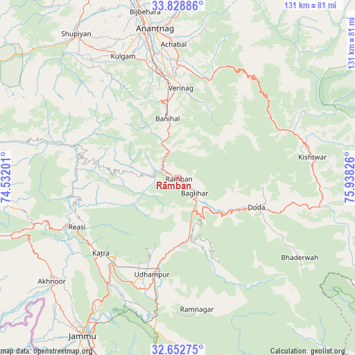
Rāmban GPS coordinates[2]
33° 14' 34.008" North, 75° 14' 6.468" East
| Map corner | latitude | longitude |
|---|---|---|
| Upper-left | 33.82886°, | 74.53201° |
| Center: | 33.24278°, | 75.23513° |
| Lower-right: | 32.65275°, | 75.93826° |
| Map W x H: | 130.8×130.8 km | = 81.3×81.3mi |
| max Lat: | 34.9274° ⇑0.9% North |
| Rāmban: | 33.24278° |
| min Lat: | ⇓99.1% South 8.09008° |
| min Long | Rāmban | max Long |
| 68.82655° | 75.23513° | 96.81° |
| W 19.3%⇐ | ⇒80.7% E |
Elevation
Elevation of Rāmban is 724 m = 2375 ft, and this is 428.4 m = 1406 ft above average elevation for this country.
| Max E: |
3681 m = 12077 ft | 7.4% |
| Rāmban | 724 m 2375 ft | |
| Avg. | 295.6 m = 970 ft | |
Min E: |
1 m = 3 ft | 92.6% |
See also: India elevation on elevation.city.
Geographical zone
Rāmban is located in North temperate zone (between Tropic of Cancer and the Arctic Circle). Distance of this Northern Tropic circle is 1090.3 km =677.5 mi to South.| Distance of | km | miles | from Rāmban |
|---|---|---|---|
| North Pole | 6310.8 | 3921.3 | to North |
| Arctic Circle | 3704.9 | 2302.1 | to North |
| Tropic Cancer | 1090.3 | 677.5 | to South |
| Equator | 3696.3 | 2296.8 | to South |


Nearby cities:
15 places around Rāmban: (largest is in red/bold)
• Akhnūr
62.7 km =39 mi,  228°
228°
• Anantnag
54.8 km =34.1 mi,  352°
352°
• Banihāl
21.8 km =13.5 mi, 350°
• Batoti
15.5 km =9.6 mi,  153°
153°
• Bhadarwāh
53.6 km =33.3 mi,  123°
123°
• Bijbehara
62.4 km =38.8 mi, 349°
• Doda
30.9 km =19.2 mi,  109°
109°
• Katra
39.7 km =24.7 mi, 225°
• Kishtwār
50.1 km =31.1 mi,  80°
80°
• Kulgam
49 km =30.4 mi,  335°
335°
• Kūd
19.5 km =12.1 mi,  165°
165°
• Qāzigund
44.8 km =27.8 mi, 348°
• Riāsi
41.6 km =25.8 mi,  244°
244°
• Rāmnagar
48.9 km =30.4 mi, 171°
• Udhampur
36.6 km =22.7 mi,  194°
194°
Sources, notices
• [Note1] Compared only with cities in India existing in our database
• [Src1] Map data: © OpenStreetMap contributors (CC-BY-SA)
• [Src2] Other city data from geonames.org with taken over terms of usage.
• [Src3] Geographical zone / Annual Mean Temperature by Robert A. Rohde @ Wikipedia
