Kāmārhāti geodata
Kāmārhāti (West Bengal) is a populated place; located in India in Asia/Kolkata (GMT+5.5) time zone. With population of 332,965 people, there are 128 cities with bigger population in this country. Compared to other cities in India, 51.3% of cities are located further ↑North; 93.4% of cities are located further ←West and 98.3% of cities have higher elevation than Kāmārhāti. Note1


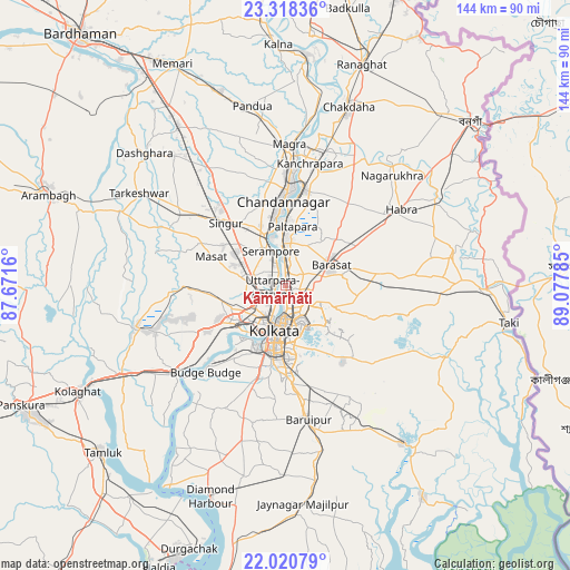
Kāmārhāti GPS coordinates[2]
22° 40' 15.996" North, 88° 22' 28.992" East
| Map corner | latitude | longitude |
|---|---|---|
| Upper-left | 23.31836°, | 87.6716° |
| Center: | 22.67111°, | 88.37472° |
| Lower-right: | 22.02079°, | 89.07785° |
| Map W x H: | 144.3×144.3 km | = 89.7×89.7mi |
| max Lat: | 34.9274° ⇑51.3% North |
| Kāmārhāti: | 22.67111° |
| min Lat: | ⇓48.7% South 8.09008° |
| min Long | Kāmārhāti | max Long |
| 68.82655° | 88.37472° | 96.81° |
| W 93.4%⇐ | ⇒6.6% E |
Elevation
Elevation of Kāmārhāti is 8 m = 26 ft, and this is 287.6 m = 944 ft below average elevation for this country.
| Max E: |
3681 m = 12077 ft | 98.3% |
| Avg. | 295.6 m = 970 ft | |
| Kāmārhāti | 8 m = 26 ft | |
Min E: |
1 m = 3 ft | 1.7% |
See also: Kāmārhāti elevation on elevation.city.
Geographical zone
Kāmārhāti is located in North Torrid zone (between Equator and Tropic of Cancer). Distance of this Northern Tropic circle is 85.1 km =52.9 mi to North.| Distance of | km | miles | from Kāmārhāti |
|---|---|---|---|
| North Pole | 7486.3 | 4651.8 | to North |
| Arctic Circle | 4880.4 | 3032.5 | to North |
| Tropic Cancer | 85.1 | 52.9 | to North |
| Equator | 2520.8 | 1566.4 | to South |


Nearby cities:
15 places around Kāmārhāti: (largest is in red/bold)
• Baranagar
3.3 km =2.1 mi,  175°
175°
• Bāli
4.3 km =2.7 mi,  233°
233°
• Bārākpur
10.6 km =6.6 mi,  353°
353°
• Chakapara
5.1 km =3.2 mi,  211°
211°
• Dam Dam
6.5 km =4 mi,  130°
130°
• Garui
4.9 km =3 mi,  148°
148°
• Khardah
5.3 km =3.3 mi,  3°
3°
• Konnagar
4.9 km =3 mi,  320°
320°
• Krishnapur
10.8 km =6.7 mi,  269°
269°
• Madhyamgram
7.6 km =4.7 mi,  74°
74°
• Pānihāti
2.2 km =1.4 mi,  358°
358°
• Rishra
6.6 km =4.1 mi,  333°
333°
• Shrīrāmpur
9.7 km =6 mi,  339°
339°
• Sodpur
4.1 km =2.5 mi,  25°
25°
• Titāgarh
7.9 km =4.9 mi, 358°
Sources, notices
• [Note1] Compared only with cities in India existing in our database
• [Src1] Map data: © OpenStreetMap contributors (CC-BY-SA)
• [Src2] Other city data from geonames.org with taken over terms of usage.
• [Src3] Geographical zone / Annual Mean Temperature by Robert A. Rohde @ Wikipedia
