Tīrān geodata
Tīrān (Isfahan) is a seat of a second-order administrative division; located in Iran in Asia/Tehran (GMT+3.5) time zone. In our database, there are 232 cities with bigger population. Compared to other cities in Iran, 62.8% of cities are located further ↑North; 51.5% of cities are located further →East and 88.7% of cities have lower elevation than Tīrān. Note1


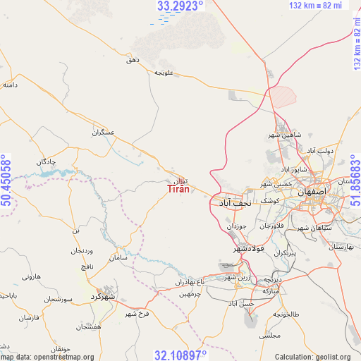
Tīrān GPS coordinates[2]
32° 42' 9.36" North, 51° 9' 13.32" East
| Map corner | latitude | longitude |
|---|---|---|
| Upper-left | 33.2923°, | 50.45058° |
| Center: | 32.7026°, | 51.1537° |
| Lower-right: | 32.10897°, | 51.85683° |
| Map W x H: | 131.6×131.6 km | = 81.8×81.8mi |
| max Lat: | 39.6482° ⇑62.8% North |
| Tīrān: | 32.7026° |
| min Lat: | ⇓37.2% South 25.2919° |
| min Long | Tīrān | max Long |
| 44.38416° | 51.1537° | 61.9965° |
| W 48.5%⇐ | ⇒51.5% E |
Elevation
Elevation of Tīrān is 1837 m = 6027 ft, and this is 788 m = 2585 ft above average elevation for this country.
| Max E: |
2564 m = 8412 ft | 11.3% |
| Tīrān | 1837 m 6027 ft | |
| Avg. | 1049 m = 3442 ft | |
Min E: |
-24 m = -79 ft | 88.7% |
See also: Iran elevation on elevation.city.
Geographical zone
Tīrān is located in North temperate zone (between Tropic of Cancer and the Arctic Circle). Distance of this Northern Tropic circle is 1030.3 km =640.2 mi to South.| Distance of | km | miles | from Tīrān |
|---|---|---|---|
| North Pole | 6370.9 | 3958.7 | to North |
| Arctic Circle | 3765 | 2339.5 | to North |
| Tropic Cancer | 1030.3 | 640.2 | to South |
| Equator | 3636.2 | 2259.4 | to South |


Nearby cities:
15 places around Tīrān: (largest is in red/bold)
• Abrīsham
42.5 km =26.4 mi,  112°
112°
• Chādegān
49.6 km =30.8 mi,  278°
278°
• Dorcheh Pīāz
38.9 km =24.2 mi,  104°
104°
• Falāvarjān
37.1 km =23.1 mi,  116°
116°
• Farrokh Shahr
50.6 km =31.4 mi,  198°
198°
• Isfahan
49.1 km =30.5 mi, 96°
• Kelīshād va Sūdarjān
38.8 km =24.1 mi, 115°
• Khomeynī Shahr
35.8 km =22.2 mi,  93°
93°
• Mobārakeh
51.5 km =32 mi,  140°
140°
• Najafābād
21.3 km =13.2 mi, 110°
• Qahderījān
31.5 km =19.6 mi, 116°
• Rehnān
42 km =26.1 mi, 92°
• Shahr-e Kord
50.3 km =31.3 mi,  213°
213°
• Shāhīn Shahr
41.1 km =25.5 mi,  65°
65°
• Zarrīn Shahr
40.6 km =25.2 mi,  149°
149°
Sources, notices
• [Note1] Compared only with cities in Iran existing in our database
• [Src1] Map data: © OpenStreetMap contributors (CC-BY-SA)
• [Src2] Other city data from geonames.org with taken over terms of usage.
• [Src3] Geographical zone / Annual Mean Temperature by Robert A. Rohde @ Wikipedia
