Chādegān geodata
Chādegān (Isfahan) is a seat of a second-order administrative division; located in Iran in Asia/Tehran (GMT+3.5) time zone. In our database, there are 232 cities with bigger population. Compared to other cities in Iran, 62.6% of cities are located further ↑North; 56.5% of cities are located further →East and 96.1% of cities have lower elevation than Chādegān. Note1


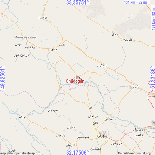
Chādegān GPS coordinates[2]
32° 46' 5.7" North, 50° 37' 43.428" East
| Map corner | latitude | longitude |
|---|---|---|
| Upper-left | 33.35751°, | 49.92561° |
| Center: | 32.76825°, | 50.62873° |
| Lower-right: | 32.17506°, | 51.33186° |
| Map W x H: | 131.5×131.5 km | = 81.7×81.7mi |
| max Lat: | 39.6482° ⇑62.6% North |
| Chādegān: | 32.76825° |
| min Lat: | ⇓37.4% South 25.2919° |
| min Long | Chādegān | max Long |
| 44.38416° | 50.62873° | 61.9965° |
| W 43.5%⇐ | ⇒56.5% E |
Elevation
Elevation of Chādegān is 2113 m = 6932 ft, and this is 1064 m = 3491 ft above average elevation for this country.
| Max E: |
2564 m = 8412 ft | 3.9% |
| Chādegān | 2113 m 6932 ft | |
| Avg. | 1049 m = 3442 ft | |
Min E: |
-24 m = -79 ft | 96.1% |
See also: Iran elevation on elevation.city.
Geographical zone
Chādegān is located in North temperate zone (between Tropic of Cancer and the Arctic Circle). Distance of this Northern Tropic circle is 1037.6 km =644.7 mi to South.| Distance of | km | miles | from Chādegān |
|---|---|---|---|
| North Pole | 6363.6 | 3954.2 | to North |
| Arctic Circle | 3757.7 | 2334.9 | to North |
| Tropic Cancer | 1037.6 | 644.7 | to South |
| Equator | 3643.5 | 2264 | to South |


Nearby cities:
15 places around Chādegān: (largest is in red/bold)
• Ardal
85.5 km =53.1 mi,  177°
177°
• Chelgard
58.1 km =36.1 mi,  234°
234°
• Dārān
31.7 km =19.7 mi,  320°
320°
• Fareydūnshahr
51.2 km =31.8 mi,  292°
292°
• Farrokh Shahr
64.3 km =40 mi,  149°
149°
• Fārsān
57.2 km =35.5 mi,  186°
186°
• Golpāyegān
82.5 km =51.3 mi,  337°
337°
• Khomeynī Shahr
85.4 km =53.1 mi,  96°
96°
• Khvānsār
58.2 km =36.2 mi,  329°
329°
• Najafābād
70.6 km =43.9 mi, 102°
• Qahderījān
80.2 km =49.8 mi,  105°
105°
• Shahr-e Kord
53.6 km =33.3 mi,  156°
156°
• Shalamzār
82.2 km =51.1 mi,  167°
167°
• Tīrān
49.6 km =30.8 mi, 98°
• Zarrīn Shahr
81.7 km =50.8 mi,  120°
120°
Sources, notices
• [Note1] Compared only with cities in Iran existing in our database
• [Src1] Map data: © OpenStreetMap contributors (CC-BY-SA)
• [Src2] Other city data from geonames.org with taken over terms of usage.
• [Src3] Geographical zone / Annual Mean Temperature by Robert A. Rohde @ Wikipedia
