Dorcheh Pīāz geodata
Dorcheh Pīāz (Isfahan) is a populated place; located in Iran in Asia/Tehran (GMT+3.5) time zone. With population of 37,462 people, there are 160 cities with bigger population in this country. Compared to other cities in Iran, 64.2% of cities are located further ↑North; 54.9% of cities are located further ←West and 76.9% of cities have lower elevation than Dorcheh Pīāz. Note1


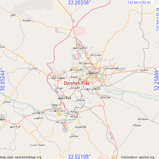
Dorcheh Pīāz GPS coordinates[2]
32° 36' 55.008" North, 51° 33' 20.016" East
| Map corner | latitude | longitude |
|---|---|---|
| Upper-left | 33.20556°, | 50.85244° |
| Center: | 32.61528°, | 51.55556° |
| Lower-right: | 32.02108°, | 52.25869° |
| Map W x H: | 131.7×131.7 km | = 81.8×81.8mi |
| max Lat: | 39.6482° ⇑64.2% North |
| Dorcheh Pīāz: | 32.61528° |
| min Lat: | ⇓35.8% South 25.2919° |
| min Long | Dorcheh Pīāz | max Long |
| 44.38416° | 51.55556° | 61.9965° |
| W 54.9%⇐ | ⇒45.1% E |
Elevation
Elevation of Dorcheh Pīāz is 1599 m = 5246 ft, and this is 550 m = 1804 ft above average elevation for this country.
| Max E: |
2564 m = 8412 ft | 23.1% |
| Dorcheh Pīāz | 1599 m 5246 ft | |
| Avg. | 1049 m = 3442 ft | |
Min E: |
-24 m = -79 ft | 76.9% |
See also: Iran elevation on elevation.city.
Geographical zone
Dorcheh Pīāz is located in North temperate zone (between Tropic of Cancer and the Arctic Circle). Distance of this Northern Tropic circle is 1020.6 km =634.2 mi to South.| Distance of | km | miles | from Dorcheh Pīāz |
|---|---|---|---|
| North Pole | 6380.6 | 3964.7 | to North |
| Arctic Circle | 3774.7 | 2345.5 | to North |
| Tropic Cancer | 1020.6 | 634.2 | to South |
| Equator | 3626.5 | 2253.4 | to South |


Nearby cities:
15 places around Dorcheh Pīāz: (largest is in red/bold)
• Abrīsham
6.8 km =4.2 mi,  165°
165°
• Dowlatābād
24.3 km =15.1 mi,  32°
32°
• Falāvarjān
7.9 km =4.9 mi,  212°
212°
• Farrokh Shahr
66.1 km =41.1 mi,  234°
234°
• Isfahan
11.9 km =7.4 mi,  69°
69°
• Kelīshād va Sūdarjān
7.6 km =4.7 mi,  200°
200°
• Khomeynī Shahr
8 km =5 mi,  346°
346°
• Mobārakeh
30.3 km =18.8 mi,  189°
189°
• Najafābād
17.8 km =11.1 mi,  276°
276°
• Qahderījān
10.4 km =6.5 mi,  245°
245°
• Rehnān
8.7 km =5.4 mi, 29°
• Shahr-e Kord
73 km =45.4 mi,  243°
243°
• Shāhīn Shahr
27 km =16.8 mi,  359°
359°
• Tīrān
38.9 km =24.2 mi, 284°
• Zarrīn Shahr
30.2 km =18.8 mi, 213°
Sources, notices
• [Note1] Compared only with cities in Iran existing in our database
• [Src1] Map data: © OpenStreetMap contributors (CC-BY-SA)
• [Src2] Other city data from geonames.org with taken over terms of usage.
• [Src3] Geographical zone / Annual Mean Temperature by Robert A. Rohde @ Wikipedia
