Farrokh Shahr geodata
Farrokh Shahr (Chaharmahal and Bakhtiari) is a populated place; located in Iran in Asia/Tehran (GMT+3.5) time zone. With population of 32,391 people, there are 171 cities with bigger population in this country. Compared to other cities in Iran, 67.8% of cities are located further ↑North; 53.3% of cities are located further →East and 95.9% of cities have lower elevation than Farrokh Shahr. Note1


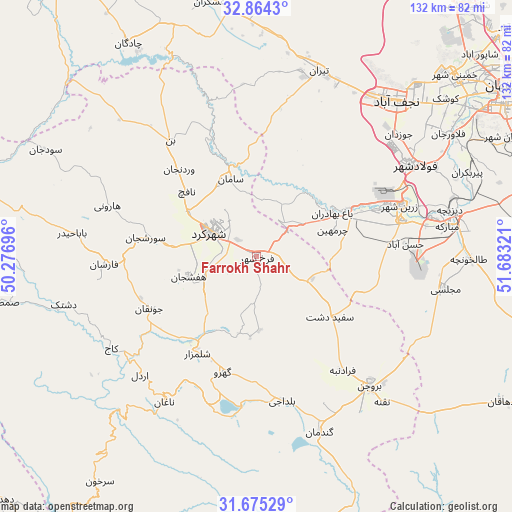
Farrokh Shahr GPS coordinates[2]
32° 16' 18.264" North, 50° 58' 48.288" East
| Map corner | latitude | longitude |
|---|---|---|
| Upper-left | 32.8643°, | 50.27696° |
| Center: | 32.27174°, | 50.98008° |
| Lower-right: | 31.67529°, | 51.68321° |
| Map W x H: | 132.2×132.2 km | = 82.1×82.1mi |
| max Lat: | 39.6482° ⇑67.8% North |
| Farrokh Shahr: | 32.27174° |
| min Lat: | ⇓32.2% South 25.2919° |
| min Long | Farrokh Shahr | max Long |
| 44.38416° | 50.98008° | 61.9965° |
| W 46.7%⇐ | ⇒53.3% E |
Elevation
Elevation of Farrokh Shahr is 2106 m = 6909 ft, and this is 1057 m = 3468 ft above average elevation for this country.
| Max E: |
2564 m = 8412 ft | 4.1% |
| Farrokh Shahr | 2106 m 6909 ft | |
| Avg. | 1049 m = 3442 ft | |
Min E: |
-24 m = -79 ft | 95.9% |
See also: Iran elevation on elevation.city.
Geographical zone
Farrokh Shahr is located in North temperate zone (between Tropic of Cancer and the Arctic Circle). Distance of this Northern Tropic circle is 982.4 km =610.4 mi to South.| Distance of | km | miles | from Farrokh Shahr |
|---|---|---|---|
| North Pole | 6418.8 | 3988.5 | to North |
| Arctic Circle | 3812.9 | 2369.2 | to North |
| Tropic Cancer | 982.4 | 610.4 | to South |
| Equator | 3588.3 | 2229.7 | to South |


Nearby cities:
15 places around Farrokh Shahr: (largest is in red/bold)
• Abrīsham
64 km =39.8 mi,  60°
60°
• Ardal
42.5 km =26.4 mi,  224°
224°
• Borūjen
44.7 km =27.8 mi,  139°
139°
• Chādegān
64.3 km =40 mi,  329°
329°
• Dorcheh Pīāz
66.1 km =41.1 mi,  54°
54°
• Falāvarjān
58.9 km =36.6 mi, 57°
• Fārsān
39.4 km =24.5 mi,  267°
267°
• Kelīshād va Sūdarjān
60.1 km =37.3 mi, 58°
• Mobārakeh
50 km =31.1 mi,  80°
80°
• Najafābād
54.2 km =33.7 mi,  41°
41°
• Qahderījān
56 km =34.8 mi, 52°
• Shahr-e Kord
13 km =8.1 mi,  297°
297°
• Shalamzār
29.4 km =18.3 mi,  211°
211°
• Tīrān
50.6 km =31.4 mi,  18°
18°
• Zarrīn Shahr
39.5 km =24.5 mi,  70°
70°
Sources, notices
• [Note1] Compared only with cities in Iran existing in our database
• [Src1] Map data: © OpenStreetMap contributors (CC-BY-SA)
• [Src2] Other city data from geonames.org with taken over terms of usage.
• [Src3] Geographical zone / Annual Mean Temperature by Robert A. Rohde @ Wikipedia
