Dowlatābād geodata
Dowlatābād (Isfahan) is a seat of a second-order administrative division; located in Iran in Asia/Tehran (GMT+3.5) time zone. With population of 33,607 people, there are 169 cities with bigger population in this country. Compared to other cities in Iran, 62.4% of cities are located further ↑North; 57.4% of cities are located further ←West and 74.1% of cities have lower elevation than Dowlatābād. Note1


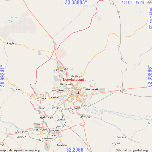
Dowlatābād GPS coordinates[2]
32° 47' 59.208" North, 51° 41' 43.908" East
| Map corner | latitude | longitude |
|---|---|---|
| Upper-left | 33.38883°, | 50.99241° |
| Center: | 32.79978°, | 51.69553° |
| Lower-right: | 32.2068°, | 52.39866° |
| Map W x H: | 131.4×131.4 km | = 81.6×81.6mi |
| max Lat: | 39.6482° ⇑62.4% North |
| Dowlatābād: | 32.79978° |
| min Lat: | ⇓37.6% South 25.2919° |
| min Long | Dowlatābād | max Long |
| 44.38416° | 51.69553° | 61.9965° |
| W 57.4%⇐ | ⇒42.6% E |
Elevation
Elevation of Dowlatābād is 1569 m = 5148 ft, and this is 520 m = 1706 ft above average elevation for this country.
| Max E: |
2564 m = 8412 ft | 25.9% |
| Dowlatābād | 1569 m 5148 ft | |
| Avg. | 1049 m = 3442 ft | |
Min E: |
-24 m = -79 ft | 74.1% |
See also: Iran elevation on elevation.city.
Geographical zone
Dowlatābād is located in North temperate zone (between Tropic of Cancer and the Arctic Circle). Distance of this Northern Tropic circle is 1041.1 km =646.9 mi to South.| Distance of | km | miles | from Dowlatābād |
|---|---|---|---|
| North Pole | 6360.1 | 3952 | to North |
| Arctic Circle | 3754.2 | 2332.8 | to North |
| Tropic Cancer | 1041.1 | 646.9 | to South |
| Equator | 3647 | 2266.1 | to South |


Nearby cities:
15 places around Dowlatābād: (largest is in red/bold)
• Abrīsham
29.4 km =18.3 mi,  202°
202°
• Dorcheh Pīāz
24.3 km =15.1 mi,  212°
212°
• Falāvarjān
32.3 km =20.1 mi, 212°
• Farrokh Shahr
89.1 km =55.4 mi,  228°
228°
• Isfahan
16.5 km =10.3 mi,  186°
186°
• Kelīshād va Sūdarjān
31.8 km =19.8 mi, 209°
• Khomeynī Shahr
19.6 km =12.2 mi, 229°
• Mobārakeh
53.5 km =33.2 mi, 199°
• Najafābād
35.8 km =22.2 mi,  239°
239°
• Naţanz
81.8 km =50.8 mi,  14°
14°
• Qahderījān
33.5 km =20.8 mi,  222°
222°
• Rehnān
15.7 km =9.8 mi, 214°
• Shāhīn Shahr
14.8 km =9.2 mi,  295°
295°
• Tīrān
51.8 km =32.2 mi,  257°
257°
• Zarrīn Shahr
54.5 km =33.9 mi, 213°
Sources, notices
• [Note1] Compared only with cities in Iran existing in our database
• [Src1] Map data: © OpenStreetMap contributors (CC-BY-SA)
• [Src2] Other city data from geonames.org with taken over terms of usage.
• [Src3] Geographical zone / Annual Mean Temperature by Robert A. Rohde @ Wikipedia
