Stykkishólmur geodata
Stykkishólmur (West) is a populated place; located in Iceland in Atlantic/Reykjavik (GMT+0) time zone. With population of 1,108 people, there are 27 cities with bigger population in this country. Compared to other cities in Iceland, 63% of cities are located further ↓South; 89.1% of cities are located further →East and 65.2% of cities have higher elevation than Stykkishólmur. Note1


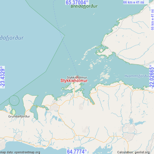
Stykkishólmur GPS coordinates[2]
65° 4' 31.332" North, 22° 43' 47.172" West
| Map corner | latitude | longitude |
|---|---|---|
| Upper-left | 65.37004°, | -23.4329° |
| Center: | 65.07537°, | -22.72977° |
| Lower-right: | 64.7774°, | -22.02665° |
| Map W x H: | 65.9×65.9 km | = 40.9×40.9mi |
| max Lat: | 66.15917° ⇑37% North |
| Stykkishólmur: | 65.07537° |
| min Lat: | ⇓63% South 63.44273° |
| min Long | Stykkishólmur | max Long |
| -23.99596° | -22.72977° | -13.68368° |
| W 10.9%⇐ | ⇒89.1% E |
Elevation
Elevation of Stykkishólmur is 10 m = 33 ft, and this is 11.3 m = 37 ft below average elevation for this country.
| Max E: |
105 m = 344 ft | 65.2% |
| Avg. | 21.3 m = 70 ft | |
| Stykkishólmur | 10 m = 33 ft | |
Min E: |
1 m = 3 ft | 34.8% |
See also: Iceland elevation on elevation.city.
Geographical zone
Stykkishólmur is located in North temperate zone (between Tropic of Cancer and the Arctic Circle). Distance of this North polar circle is 165.5 km =102.8 mi to North.| Distance of | km | miles | from Stykkishólmur |
|---|---|---|---|
| North Pole | 2771.4 | 1722.1 | to North |
| Arctic Circle | 165.5 | 102.8 | to North |
| Tropic Cancer | 4629.8 | 2876.8 | to South |
| Equator | 7235.7 | 4496.1 | to South |


Nearby cities:
15 places around Stykkishólmur: (largest is in red/bold)
• Akranes
89.4 km =55.6 mi,  159°
159°
• Borgarnes
70.9 km =44.1 mi,  147°
147°
• Garður
112.3 km =69.8 mi,  177°
177°
• Grundarfjörður
30.2 km =18.8 mi,  236°
236°
• Grundarhverfi
102.1 km =63.4 mi, 155°
• Hvammstangi
90.6 km =56.3 mi,  66°
66°
• Kópavogur
113.9 km =70.8 mi, 160°
• Mosfellsbær
112.3 km =69.8 mi, 154°
• Patreksfjörður
82.6 km =51.3 mi,  314°
314°
• Reykjavík
111.8 km =69.5 mi, 159°
• Sandgerði
115.4 km =71.7 mi, 179°
• Seltjarnarnes
108.4 km =67.4 mi, 161°
• Álftanes
113.7 km =70.6 mi, 162°
• Ísafjörður
112.7 km =70 mi,  350°
350°
• Ólafsvík
50.3 km =31.3 mi,  246°
246°
Sources, notices
• [Note1] Compared only with cities in Iceland existing in our database
• [Src1] Map data: © OpenStreetMap contributors (CC-BY-SA)
• [Src2] Other city data from geonames.org with taken over terms of usage.
• [Src3] Geographical zone / Annual Mean Temperature by Robert A. Rohde @ Wikipedia
