Selfoss geodata
Selfoss (South) is a seat of a first-order administrative division; located in Iceland in Atlantic/Reykjavik (GMT+0) time zone. With population of 6,510 people, there are 7 cities with bigger population in this country. Compared to other cities in Iceland, 87% of cities are located further ↑North; 54.3% of cities are located further ←West and 50% of cities have lower elevation than Selfoss. Note1


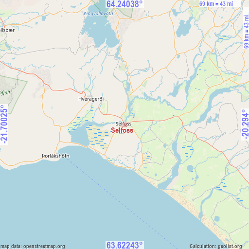
Selfoss GPS coordinates[2]
63° 55' 59.196" North, 20° 59' 49.632" West
| Map corner | latitude | longitude |
|---|---|---|
| Upper-left | 64.24038°, | -21.70025° |
| Center: | 63.93311°, | -20.99712° |
| Lower-right: | 63.62243°, | -20.294° |
| Map W x H: | 68.7×68.7 km | = 42.7×42.7mi |
| max Lat: | 66.15917° ⇑87% North |
| Selfoss: | 63.93311° |
| min Lat: | ⇓13% South 63.44273° |
| min Long | Selfoss | max Long |
| -23.99596° | -20.99712° | -13.68368° |
| W 54.3%⇐ | ⇒45.7% E |
Elevation
Elevation of Selfoss is 16 m = 52 ft, and this is 5.3 m = 17 ft below average elevation for this country.
| Max E: |
105 m = 344 ft | 50% |
| Avg. | 21.3 m = 70 ft | |
| Selfoss | 16 m = 52 ft | |
Min E: |
1 m = 3 ft | 50% |
See also: Iceland elevation on elevation.city.
Geographical zone
Selfoss is located in North temperate zone (between Tropic of Cancer and the Arctic Circle). Distance of this North polar circle is 292.5 km =181.8 mi to North.| Distance of | km | miles | from Selfoss |
|---|---|---|---|
| North Pole | 2898.4 | 1801 | to North |
| Arctic Circle | 292.5 | 181.8 | to North |
| Tropic Cancer | 4502.8 | 2797.9 | to South |
| Equator | 7108.7 | 4417.1 | to South |


Nearby cities:
15 places around Selfoss: (largest is in red/bold)
• Akranes
67.8 km =42.1 mi,  309°
309°
• Eyrarbakki
10.8 km =6.7 mi,  223°
223°
• Garðabær
48.3 km =30 mi,  290°
290°
• Grundarhverfi
53.2 km =33.1 mi, 309°
• Hafnarfjörður
48.2 km =30 mi, 288°
• Hella
31.2 km =19.4 mi,  110°
110°
• Hveragerði
11.9 km =7.4 mi, 309°
• Hvolsvöllur
43 km =26.7 mi,  118°
118°
• Kópavogur
48.9 km =30.4 mi, 294°
• Mosfellsbær
42.9 km =26.7 mi, 307°
• Reykjavík
49.2 km =30.6 mi,  297°
297°
• Seltjarnarnes
54.4 km =33.8 mi, 296°
• Vestmannaeyjar
65.2 km =40.5 mi,  146°
146°
• Álftanes
53 km =32.9 mi, 290°
• Þorlákshöfn
20.8 km =12.9 mi,  245°
245°
Sources, notices
• [Note1] Compared only with cities in Iceland existing in our database
• [Src1] Map data: © OpenStreetMap contributors (CC-BY-SA)
• [Src2] Other city data from geonames.org with taken over terms of usage.
• [Src3] Geographical zone / Annual Mean Temperature by Robert A. Rohde @ Wikipedia
