Eyrarbakki geodata
Eyrarbakki (South) is a populated place; located in Iceland in Atlantic/Reykjavik (GMT+0) time zone. With population of 531 people, there are 43 cities with bigger population in this country. Compared to other cities in Iceland, 89.1% of cities are located further ↑North; 52.2% of cities are located further ←West and 82.6% of cities have higher elevation than Eyrarbakki. Note1


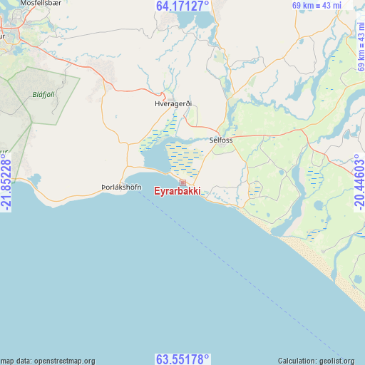
Eyrarbakki GPS coordinates[2]
63° 51' 47.628" North, 21° 8' 56.94" West
| Map corner | latitude | longitude |
|---|---|---|
| Upper-left | 64.17127°, | -21.85228° |
| Center: | 63.86323°, | -21.14915° |
| Lower-right: | 63.55178°, | -20.44603° |
| Map W x H: | 68.9×68.9 km | = 42.8×42.8mi |
| max Lat: | 66.15917° ⇑89.1% North |
| Eyrarbakki: | 63.86323° |
| min Lat: | ⇓10.9% South 63.44273° |
| min Long | Eyrarbakki | max Long |
| -23.99596° | -21.14915° | -13.68368° |
| W 52.2%⇐ | ⇒47.8% E |
Elevation
Elevation of Eyrarbakki is 3 m = 10 ft, and this is 18.3 m = 60 ft below average elevation for this country.
| Max E: |
105 m = 344 ft | 82.6% |
| Avg. | 21.3 m = 70 ft | |
| Eyrarbakki | 3 m = 10 ft | |
Min E: |
1 m = 3 ft | 17.4% |
See also: Iceland elevation on elevation.city.
Geographical zone
Eyrarbakki is located in North temperate zone (between Tropic of Cancer and the Arctic Circle). Distance of this North polar circle is 300.2 km =186.5 mi to North.| Distance of | km | miles | from Eyrarbakki |
|---|---|---|---|
| North Pole | 2906.1 | 1805.8 | to North |
| Arctic Circle | 300.2 | 186.5 | to North |
| Tropic Cancer | 4495 | 2793.1 | to South |
| Equator | 7100.9 | 4412.3 | to South |


Nearby cities:
15 places around Eyrarbakki: (largest is in red/bold)
• Garðabær
45.3 km =28.1 mi,  303°
303°
• Grindavík
63.3 km =39.3 mi,  267°
267°
• Grundarhverfi
53.7 km =33.4 mi,  321°
321°
• Hafnarfjörður
44.7 km =27.8 mi, 300°
• Hella
36.8 km =22.9 mi,  94°
94°
• Hveragerði
15.4 km =9.6 mi,  353°
353°
• Hvolsvöllur
47.1 km =29.3 mi,  105°
105°
• Kópavogur
46.4 km =28.8 mi,  306°
306°
• Mosfellsbær
43.1 km =26.8 mi, 321°
• Reykjavík
47.3 km =29.4 mi, 309°
• Selfoss
10.8 km =6.7 mi,  43°
43°
• Seltjarnarnes
52.3 km =32.5 mi, 308°
• Vogar
61.8 km =38.4 mi,  282°
282°
• Álftanes
49.8 km =30.9 mi, 301°
• Þorlákshöfn
11.5 km =7.1 mi, 265°
Sources, notices
• [Note1] Compared only with cities in Iceland existing in our database
• [Src1] Map data: © OpenStreetMap contributors (CC-BY-SA)
• [Src2] Other city data from geonames.org with taken over terms of usage.
• [Src3] Geographical zone / Annual Mean Temperature by Robert A. Rohde @ Wikipedia
