Vestmannaeyjar geodata
Vestmannaeyjar (South) is a populated place; located in Iceland in Atlantic/Reykjavik (GMT+0) time zone. With population of 4,219 people, there are 9 cities with bigger population in this country. Compared to other cities in Iceland, 100% of cities are located further ↑North; 65.2% of cities are located further ←West and 63% of cities have lower elevation than Vestmannaeyjar. Note1


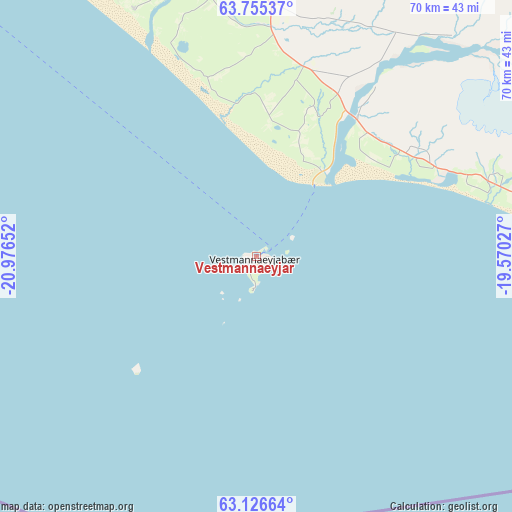
Vestmannaeyjar GPS coordinates[2]
63° 26' 33.828" North, 20° 16' 24.204" West
| Map corner | latitude | longitude |
|---|---|---|
| Upper-left | 63.75537°, | -20.97652° |
| Center: | 63.44273°, | -20.27339° |
| Lower-right: | 63.12664°, | -19.57027° |
| Map W x H: | 69.9×69.9 km | = 43.4×43.4mi |
| max Lat: | 66.15917° ⇑100% North |
| Vestmannaeyjar: | 63.44273° |
| min Lat: | ⇓0% South 63.44273° |
| min Long | Vestmannaeyjar | max Long |
| -23.99596° | -20.27339° | -13.68368° |
| W 65.2%⇐ | ⇒34.8% E |
Elevation
Elevation of Vestmannaeyjar is 25 m = 82 ft, and this is 3.7 m = 12 ft above average elevation for this country.
| Max E: |
105 m = 344 ft | 37% |
| Vestmannaeyjar | 25 m 82 ft | |
| Avg. | 21.3 m = 70 ft | |
Min E: |
1 m = 3 ft | 63% |
See also: Iceland elevation on elevation.city.
Geographical zone
Vestmannaeyjar is located in North temperate zone (between Tropic of Cancer and the Arctic Circle). Distance of this North polar circle is 347 km =215.6 mi to North.| Distance of | km | miles | from Vestmannaeyjar |
|---|---|---|---|
| North Pole | 2952.9 | 1834.8 | to North |
| Arctic Circle | 347 | 215.6 | to North |
| Tropic Cancer | 4448.3 | 2764 | to South |
| Equator | 7054.2 | 4383.3 | to South |


Nearby cities:
15 places around Vestmannaeyjar: (largest is in red/bold)
• Eyrarbakki
63.7 km =39.6 mi,  317°
317°
• Garðabær
108.3 km =67.3 mi,  311°
311°
• Grindavík
115.6 km =71.8 mi,  292°
292°
• Grundarhverfi
117.2 km =72.8 mi, 319°
• Hafnarfjörður
107.3 km =66.7 mi, 310°
• Hella
44 km =27.3 mi,  351°
351°
• Hveragerði
76.6 km =47.6 mi, 324°
• Hvolsvöllur
34.3 km =21.3 mi,  4°
4°
• Kópavogur
109.7 km =68.2 mi, 312°
• Mosfellsbær
106.7 km =66.3 mi, 318°
• Reykjavík
110.8 km =68.8 mi, 314°
• Selfoss
65.2 km =40.5 mi,  326°
326°
• Seltjarnarnes
115.7 km =71.9 mi, 313°
• Álftanes
112.6 km =70 mi, 310°
• Þorlákshöfn
71.5 km =44.4 mi, 309°
Sources, notices
• [Note1] Compared only with cities in Iceland existing in our database
• [Src1] Map data: © OpenStreetMap contributors (CC-BY-SA)
• [Src2] Other city data from geonames.org with taken over terms of usage.
• [Src3] Geographical zone / Annual Mean Temperature by Robert A. Rohde @ Wikipedia
