Valguarnera Caropepe geodata
Valguarnera Caropepe (Sicily) is a seat of a third-order administrative division; located in Italy in Europe/Rome (GMT+2) time zone. With population of 7,453 people, there are 1305 cities with bigger population in this country. Compared to other cities in Italy, 98.9% of cities are located further ↑North; 81.7% of cities are located further ←West and 84.1% of cities have lower elevation than Valguarnera Caropepe. Note1
Current local time in Valguarnera Caropepe:
09:37 PM, WednesdayDifference from your time zone: hours


Valguarnera Caropepe GPS coordinates[2]
37° 29' 42.972" North, 14° 23' 24.9" East
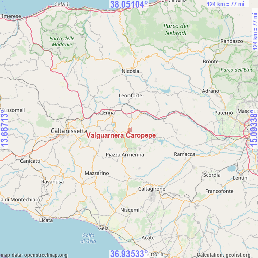
| Map corner | latitude | longitude |
|---|---|---|
| Upper-left | 38.05104°, | 13.68713° |
| Center: | 37.49527°, | 14.39025° |
| Lower-right: | 36.93533°, | 15.09338° |
| Map W x H: | 124.1×124.1 km | = 77.1×77.1mi |
| max Lat: | 47.04031° ⇑98.9% North |
| Valguarnera Caropepe: | 37.49527° |
| min Lat: | ⇓1.1% South 35.50142° |
| min Long | Valguarnera Car | max Long |
| 6.69888° | 14.39025° | 18.48682° |
| W 81.7%⇐ | ⇒18.3% E |
Elevation
Elevation of Valguarnera Caropepe is 593 m = 1946 ft, and this is 286.3 m = 939 ft above average elevation for this country.
| Max E: |
2085 m = 6841 ft | 15.9% |
| Valguarnera Caropepe | 593 m 1946 ft | |
| Avg. | 306.7 m = 1006 ft | |
Min E: |
-4 m = -13 ft | 84.1% |
See also: Italy elevation on elevation.city.
Geographical zone
Valguarnera Caropepe is located in North temperate zone (between Tropic of Cancer and the Arctic Circle). Distance of this Northern Tropic circle is 1563.2 km =971.3 mi to South.| Distance of | km | miles | from Valguarnera Caropepe |
|---|---|---|---|
| North Pole | 5838 | 3627.6 | to North |
| Arctic Circle | 3232.1 | 2008.3 | to North |
| Tropic Cancer | 1563.2 | 971.3 | to South |
| Equator | 4169.1 | 2590.6 | to South |


Nearby cities:
15 places around Valguarnera Caropepe: (largest is in red/bold)
• Agira
21.2 km =13.2 mi,  32°
32°
• Aidone
10.2 km =6.3 mi,  151°
151°
• Assoro
14.3 km =8.9 mi,  9°
9°
• Barrafranca
21 km =13 mi,  231°
231°
• Calascibetta
14.9 km =9.3 mi,  315°
315°
• Carrubbo
21.6 km =13.4 mi,  90°
90°
• Enna
12.9 km =8 mi,  307°
307°
• Leonforte
16.3 km =10.1 mi,  2°
2°
• Mirabella Imbaccari
19.3 km =12 mi,  165°
165°
• Nissoria
18.4 km =11.4 mi,  16°
16°
• Pergusa
8.1 km =5 mi,  293°
293°
• Piazza Armerina
12.5 km =7.8 mi,  188°
188°
• Raddusa
13 km =8.1 mi,  99°
99°
• San Giorgio
17.5 km =10.9 mi, 23°
• Villarosa
21.9 km =13.6 mi,  297°
297°
Sources, notices
• [Note1] Compared only with cities in Italy existing in our database
• [Src1] Map data: © OpenStreetMap contributors (CC-BY-SA)
• [Src2] Other city data from geonames.org with taken over terms of usage.
• [Src3] Geographical zone / Annual Mean Temperature by Robert A. Rohde @ Wikipedia
