Pergusa geodata
Pergusa (Sicily) is a populated place; located in Italy in Europe/Rome (GMT+1) time zone. With population of 953 people, there are 6849 cities with bigger population in this country. Compared to other cities in Italy, 98.8% of cities are located further ↑North; 80.9% of cities are located further ←West and 89.2% of cities have lower elevation than Pergusa. Note1


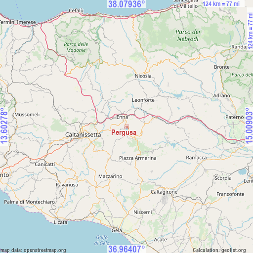
Pergusa GPS coordinates[2]
37° 31' 25.68" North, 14° 18' 21.24" East
| Map corner | latitude | longitude |
|---|---|---|
| Upper-left | 38.07936°, | 13.60278° |
| Center: | 37.5238°, | 14.3059° |
| Lower-right: | 36.96407°, | 15.00903° |
| Map W x H: | 124×124 km | = 77.1×77.1mi |
| max Lat: | 47.04031° ⇑98.8% North |
| Pergusa: | 37.5238° |
| min Lat: | ⇓1.2% South 35.50142° |
| min Long | Pergusa | max Long |
| 6.69888° | 14.3059° | 18.48682° |
| W 80.9%⇐ | ⇒19.1% E |
Elevation
Elevation of Pergusa is 698 m = 2290 ft, and this is 391.3 m = 1284 ft above average elevation for this country.
| Max E: |
2085 m = 6841 ft | 10.8% |
| Pergusa | 698 m 2290 ft | |
| Avg. | 306.7 m = 1006 ft | |
Min E: |
-4 m = -13 ft | 89.2% |
See also: Italy elevation on elevation.city.
Geographical zone
Pergusa is located in North temperate zone (between Tropic of Cancer and the Arctic Circle). Distance of this Northern Tropic circle is 1566.3 km =973.3 mi to South.| Distance of | km | miles | from Pergusa |
|---|---|---|---|
| North Pole | 5834.8 | 3625.6 | to North |
| Arctic Circle | 3228.9 | 2006.3 | to North |
| Tropic Cancer | 1566.3 | 973.3 | to South |
| Equator | 4172.3 | 2592.5 | to South |


Nearby cities:
15 places around Pergusa: (largest is in red/bold)
• Aidone
17.3 km =10.7 mi,  134°
134°
• Assoro
14.7 km =9.1 mi,  42°
42°
• Barrafranca
18.5 km =11.5 mi,  209°
209°
• Calascibetta
8 km =5 mi,  337°
337°
• Enna
5.4 km =3.4 mi,  329°
329°
• Leonforte
15.4 km =9.6 mi,  31°
31°
• Nissoria
19.2 km =11.9 mi, 40°
• Piazza Armerina
16.5 km =10.3 mi,  160°
160°
• Pietraperzia
18.9 km =11.7 mi,  231°
231°
• Raddusa
20.9 km =13 mi,  104°
104°
• San Giorgio
19.3 km =12 mi,  47°
47°
• Valguarnera Caropepe
8.1 km =5 mi,  113°
113°
• Villadoro
19.1 km =11.9 mi,  347°
347°
• Villapriolo
15.4 km =9.6 mi,  319°
319°
• Villarosa
13.9 km =8.6 mi,  300°
300°
Sources, notices
• [Note1] Compared only with cities in Italy existing in our database
• [Src1] Map data: © OpenStreetMap contributors (CC-BY-SA)
• [Src2] Other city data from geonames.org with taken over terms of usage.
• [Src3] Geographical zone / Annual Mean Temperature by Robert A. Rohde @ Wikipedia
