Aidone geodata
Aidone (Sicily) is a seat of a third-order administrative division; located in Italy in Europe/Rome (GMT+2) time zone. With population of 4,929 people, there are 1977 cities with bigger population in this country. Compared to other cities in Italy, 99.1% of cities are located further ↑North; 82.2% of cities are located further ←West and 93.7% of cities have lower elevation than Aidone. Note1


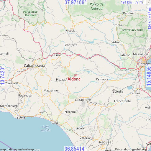
Aidone GPS coordinates[2]
37° 24' 52.848" North, 14° 26' 43.512" East
| Map corner | latitude | longitude |
|---|---|---|
| Upper-left | 37.97106°, | 13.7423° |
| Center: | 37.41468°, | 14.44542° |
| Lower-right: | 36.85414°, | 15.14855° |
| Map W x H: | 124.2×124.2 km | = 77.2×77.2mi |
| max Lat: | 47.04031° ⇑99.1% North |
| Aidone: | 37.41468° |
| min Lat: | ⇓0.9% South 35.50142° |
| min Long | Aidone | max Long |
| 6.69888° | 14.44542° | 18.48682° |
| W 82.2%⇐ | ⇒17.8% E |
Elevation
Elevation of Aidone is 825 m = 2707 ft, and this is 518.3 m = 1700 ft above average elevation for this country.
| Max E: |
2085 m = 6841 ft | 6.3% |
| Aidone | 825 m 2707 ft | |
| Avg. | 306.7 m = 1006 ft | |
Min E: |
-4 m = -13 ft | 93.7% |
See also: Italy elevation on elevation.city.
Geographical zone
Aidone is located in North temperate zone (between Tropic of Cancer and the Arctic Circle). Distance of this Northern Tropic circle is 1554.2 km =965.7 mi to South.| Distance of | km | miles | from Aidone |
|---|---|---|---|
| North Pole | 5846.9 | 3633.1 | to North |
| Arctic Circle | 3241.1 | 2013.9 | to North |
| Tropic Cancer | 1554.2 | 965.7 | to South |
| Equator | 4160.1 | 2585 | to South |


Nearby cities:
15 places around Aidone: (largest is in red/bold)
• Barrafranca
21.8 km =13.5 mi,  259°
259°
• Caltagirone
20.6 km =12.8 mi,  162°
162°
• Carrubbo
18.9 km =11.7 mi,  61°
61°
• Castel di Judica
19.9 km =12.4 mi, 63°
• Cinquegrana
20.9 km =13 mi,  71°
71°
• Enna
22.6 km =14 mi,  318°
318°
• Giumarra
19.3 km =12 mi, 69°
• Mirabella Imbaccari
9.7 km =6 mi,  179°
179°
• Pergusa
17.3 km =10.7 mi,  314°
314°
• Piazza Armerina
7.5 km =4.7 mi,  243°
243°
• Raddusa
10.4 km =6.5 mi,  49°
49°
• Ramacca
22 km =13.7 mi,  98°
98°
• San Cono
15.5 km =9.6 mi,  206°
206°
• San Michele di Ganzaria
15 km =9.3 mi,  186°
186°
• Valguarnera Caropepe
10.2 km =6.3 mi,  331°
331°
Sources, notices
• [Note1] Compared only with cities in Italy existing in our database
• [Src1] Map data: © OpenStreetMap contributors (CC-BY-SA)
• [Src2] Other city data from geonames.org with taken over terms of usage.
• [Src3] Geographical zone / Annual Mean Temperature by Robert A. Rohde @ Wikipedia
