Raddusa geodata
Raddusa (Sicily) is a seat of a third-order administrative division; located in Italy in Europe/Rome (GMT+2) time zone. With population of 3,192 people, there are 2901 cities with bigger population in this country. Compared to other cities in Italy, 99% of cities are located further ↑North; 83% of cities are located further ←West and 66.5% of cities have lower elevation than Raddusa. Note1


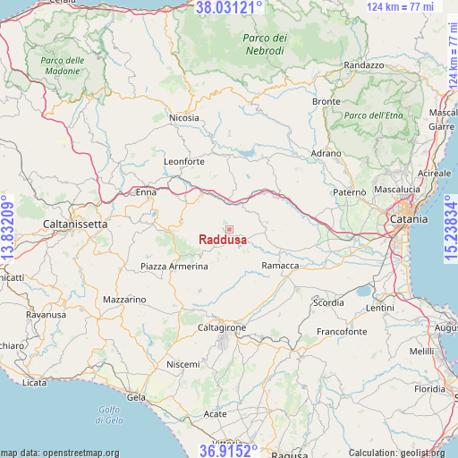
Raddusa GPS coordinates[2]
37° 28' 31.044" North, 14° 32' 6.756" East
| Map corner | latitude | longitude |
|---|---|---|
| Upper-left | 38.03121°, | 13.83209° |
| Center: | 37.47529°, | 14.53521° |
| Lower-right: | 36.9152°, | 15.23834° |
| Map W x H: | 124.1×124.1 km | = 77.1×77.1mi |
| max Lat: | 47.04031° ⇑99% North |
| Raddusa: | 37.47529° |
| min Lat: | ⇓1% South 35.50142° |
| min Long | Raddusa | max Long |
| 6.69888° | 14.53521° | 18.48682° |
| W 83%⇐ | ⇒17% E |
Elevation
Elevation of Raddusa is 358 m = 1175 ft, and this is 51.3 m = 168 ft above average elevation for this country.
| Max E: |
2085 m = 6841 ft | 33.5% |
| Raddusa | 358 m 1175 ft | |
| Avg. | 306.7 m = 1006 ft | |
Min E: |
-4 m = -13 ft | 66.5% |
See also: Italy elevation on elevation.city.
Geographical zone
Raddusa is located in North temperate zone (between Tropic of Cancer and the Arctic Circle). Distance of this Northern Tropic circle is 1560.9 km =969.9 mi to South.| Distance of | km | miles | from Raddusa |
|---|---|---|---|
| North Pole | 5840.2 | 3628.9 | to North |
| Arctic Circle | 3234.3 | 2009.7 | to North |
| Tropic Cancer | 1560.9 | 969.9 | to South |
| Equator | 4166.9 | 2589.2 | to South |


Nearby cities:
15 places around Raddusa: (largest is in red/bold)
• Agira
20.1 km =12.5 mi,  356°
356°
• Aidone
10.4 km =6.5 mi,  229°
229°
• Assoro
19.3 km =12 mi,  327°
327°
• Carrubbo
9 km =5.6 mi,  76°
76°
• Castel di Judica
10.1 km =6.3 mi, 77°
• Catenanuova
17.2 km =10.7 mi,  52°
52°
• Cinquegrana
12 km =7.5 mi,  91°
91°
• Giumarra
10.1 km =6.3 mi, 89°
• Mirabella Imbaccari
18.3 km =11.4 mi,  205°
205°
• Nissoria
21.3 km =13.2 mi,  338°
338°
• Pergusa
20.9 km =13 mi,  284°
284°
• Piazza Armerina
17.8 km =11.1 mi,  235°
235°
• Ramacca
17.1 km =10.6 mi,  125°
125°
• San Giorgio
19.3 km =12 mi, 342°
• Valguarnera Caropepe
13 km =8.1 mi, 279°
Sources, notices
• [Note1] Compared only with cities in Italy existing in our database
• [Src1] Map data: © OpenStreetMap contributors (CC-BY-SA)
• [Src2] Other city data from geonames.org with taken over terms of usage.
• [Src3] Geographical zone / Annual Mean Temperature by Robert A. Rohde @ Wikipedia
