Terravecchia geodata
Terravecchia (Calabria) is a seat of a third-order administrative division; located in Italy in Europe/Rome (GMT+2) time zone. With population of 1,019 people, there are 6585 cities with bigger population in this country. Compared to other cities in Italy, 90.5% of cities are located further ↑North; 97.9% of cities are located further ←West and 74.6% of cities have lower elevation than Terravecchia. Note1


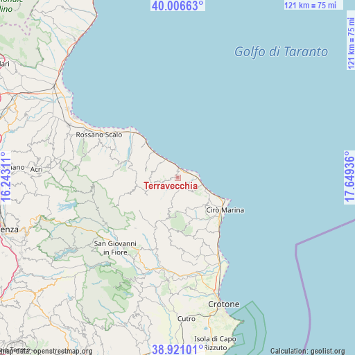
Terravecchia GPS coordinates[2]
39° 27' 57.384" North, 16° 56' 46.428" East
| Map corner | latitude | longitude |
|---|---|---|
| Upper-left | 40.00663°, | 16.24311° |
| Center: | 39.46594°, | 16.94623° |
| Lower-right: | 38.92101°, | 17.64936° |
| Map W x H: | 120.7×120.7 km | = 75×75mi |
| max Lat: | 47.04031° ⇑90.5% North |
| Terravecchia: | 39.46594° |
| min Lat: | ⇓9.5% South 35.50142° |
| min Long | Terravecchia | max Long |
| 6.69888° | 16.94623° | 18.48682° |
| W 97.9%⇐ | ⇒2.1% E |
Elevation
Elevation of Terravecchia is 447 m = 1467 ft, and this is 140.3 m = 460 ft above average elevation for this country.
| Max E: |
2085 m = 6841 ft | 25.4% |
| Terravecchia | 447 m 1467 ft | |
| Avg. | 306.7 m = 1006 ft | |
Min E: |
-4 m = -13 ft | 74.6% |
See also: Italy elevation on elevation.city.
Geographical zone
Terravecchia is located in North temperate zone (between Tropic of Cancer and the Arctic Circle). Distance of this Northern Tropic circle is 1782.3 km =1107.5 mi to South.| Distance of | km | miles | from Terravecchia |
|---|---|---|---|
| North Pole | 5618.9 | 3491.4 | to North |
| Arctic Circle | 3013 | 1872.2 | to North |
| Tropic Cancer | 1782.3 | 1107.5 | to South |
| Equator | 4388.2 | 2726.7 | to South |


Nearby cities:
15 places around Terravecchia: (largest is in red/bold)
• Bocchigliero
17.6 km =10.9 mi,  252°
252°
• Caloppezzati
16.3 km =10.1 mi,  310°
310°
• Caloveto
16.6 km =10.3 mi,  285°
285°
• Camigliano
12 km =7.5 mi,  317°
317°
• Campana
12.1 km =7.5 mi,  241°
241°
• Carfizzi
17.8 km =11.1 mi,  172°
172°
• Cariati
3.5 km =2.2 mi,  12°
12°
• Cirò
13.7 km =8.5 mi,  132°
132°
• Crucoli
6.5 km =4 mi, 131°
• Mandatoriccio
9.6 km =6 mi,  270°
270°
• Pietrapaola
11.4 km =7.1 mi,  281°
281°
• San Giacomo-Marinella
16 km =9.9 mi, 318°
• Scala Coeli
5.5 km =3.4 mi, 248°
• Torretta
7.9 km =4.9 mi,  100°
100°
• Umbriatico
12.8 km =8 mi,  190°
190°
Sources, notices
• [Note1] Compared only with cities in Italy existing in our database
• [Src1] Map data: © OpenStreetMap contributors (CC-BY-SA)
• [Src2] Other city data from geonames.org with taken over terms of usage.
• [Src3] Geographical zone / Annual Mean Temperature by Robert A. Rohde @ Wikipedia
