Cariati geodata
Cariati (Calabria) is a seat of a third-order administrative division; located in Italy in Europe/Rome (GMT+2) time zone. With population of 8,255 people, there are 1168 cities with bigger population in this country. Compared to other cities in Italy, 90.4% of cities are located further ↑North; 97.9% of cities are located further ←West and 94.8% of cities have higher elevation than Cariati. Note1


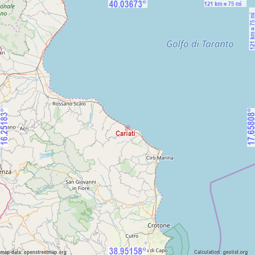
Cariati GPS coordinates[2]
39° 29' 46.572" North, 16° 57' 17.82" East
| Map corner | latitude | longitude |
|---|---|---|
| Upper-left | 40.03673°, | 16.25183° |
| Center: | 39.49627°, | 16.95495° |
| Lower-right: | 38.95158°, | 17.65808° |
| Map W x H: | 120.7×120.7 km | = 75×75mi |
| max Lat: | 47.04031° ⇑90.4% North |
| Cariati: | 39.49627° |
| min Lat: | ⇓9.6% South 35.50142° |
| min Long | Cariati | max Long |
| 6.69888° | 16.95495° | 18.48682° |
| W 97.9%⇐ | ⇒2.1% E |
Elevation
Elevation of Cariati is 9 m = 30 ft, and this is 297.7 m = 977 ft below average elevation for this country.
| Max E: |
2085 m = 6841 ft | 94.8% |
| Avg. | 306.7 m = 1006 ft | |
| Cariati | 9 m = 30 ft | |
Min E: |
-4 m = -13 ft | 5.2% |
See also: Italy elevation on elevation.city.
Geographical zone
Cariati is located in North temperate zone (between Tropic of Cancer and the Arctic Circle). Distance of this Northern Tropic circle is 1785.7 km =1109.6 mi to South.| Distance of | km | miles | from Cariati |
|---|---|---|---|
| North Pole | 5615.5 | 3489.3 | to North |
| Arctic Circle | 3009.6 | 1870.1 | to North |
| Tropic Cancer | 1785.7 | 1109.6 | to South |
| Equator | 4391.6 | 2728.8 | to South |


Nearby cities:
15 places around Cariati: (largest is in red/bold)
• Caloppezzati
15 km =9.3 mi,  298°
298°
• Caloveto
16.7 km =10.4 mi,  273°
273°
• Camigliano
10.4 km =6.5 mi, 301°
• Campana
14.6 km =9.1 mi,  231°
231°
• Cirò
15.7 km =9.8 mi,  143°
143°
• Crosia
17.7 km =11 mi, 296°
• Crucoli
8.7 km =5.4 mi,  151°
151°
• Mandatoriccio
10.9 km =6.8 mi,  252°
252°
• Mirto
19.4 km =12.1 mi,  306°
306°
• Pietrapaola
12 km =7.5 mi, 265°
• San Giacomo-Marinella
14.3 km =8.9 mi, 307°
• Scala Coeli
7.9 km =4.9 mi, 227°
• Terravecchia
3.5 km =2.2 mi,  192°
192°
• Torretta
8.4 km =5.2 mi,  124°
124°
• Umbriatico
16.2 km =10.1 mi, 191°
Sources, notices
• [Note1] Compared only with cities in Italy existing in our database
• [Src1] Map data: © OpenStreetMap contributors (CC-BY-SA)
• [Src2] Other city data from geonames.org with taken over terms of usage.
• [Src3] Geographical zone / Annual Mean Temperature by Robert A. Rohde @ Wikipedia
