Cirò geodata
Cirò (Calabria) is a seat of a third-order administrative division; located in Italy in Europe/Rome (GMT+2) time zone. With population of 2,936 people, there are 3095 cities with bigger population in this country. Compared to other cities in Italy, 90.8% of cities are located further ↑North; 98.1% of cities are located further ←West and 54.1% of cities have lower elevation than Cirò. Note1


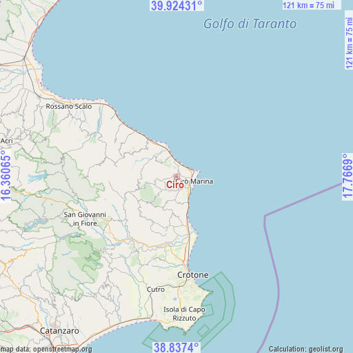
Cirò GPS coordinates[2]
39° 22' 58.692" North, 17° 3' 49.572" East
| Map corner | latitude | longitude |
|---|---|---|
| Upper-left | 39.92431°, | 16.36065° |
| Center: | 39.38297°, | 17.06377° |
| Lower-right: | 38.8374°, | 17.7669° |
| Map W x H: | 120.9×120.9 km | = 75.1×75.1mi |
| max Lat: | 47.04031° ⇑90.8% North |
| Cirò: | 39.38297° |
| min Lat: | ⇓9.2% South 35.50142° |
| min Long | Cirò | max Long |
| 6.69888° | 17.06377° | 18.48682° |
| W 98.1%⇐ | ⇒1.9% E |
Elevation
Elevation of Cirò is 260 m = 853 ft, and this is 46.7 m = 153 ft below average elevation for this country.
| Max E: |
2085 m = 6841 ft | 45.9% |
| Avg. | 306.7 m = 1006 ft | |
| Cirò | 260 m = 853 ft | |
Min E: |
-4 m = -13 ft | 54.1% |
See also: Italy elevation on elevation.city.
Geographical zone
Cirò is located in North temperate zone (between Tropic of Cancer and the Arctic Circle). Distance of this Northern Tropic circle is 1773.1 km =1101.8 mi to South.| Distance of | km | miles | from Cirò |
|---|---|---|---|
| North Pole | 5628.1 | 3497.1 | to North |
| Arctic Circle | 3022.2 | 1877.9 | to North |
| Tropic Cancer | 1773.1 | 1101.8 | to South |
| Equator | 4379 | 2721 | to South |


Nearby cities:
15 places around Cirò: (largest is in red/bold)
• Carfizzi
11.4 km =7.1 mi,  222°
222°
• Cariati
15.7 km =9.8 mi,  323°
323°
• Casabona
17.6 km =10.9 mi,  212°
212°
• Cirò Marina
5.5 km =3.4 mi,  106°
106°
• Crucoli
7.2 km =4.5 mi,  313°
313°
• Melissa
8.7 km =5.4 mi,  199°
199°
• Pallagorio
15.8 km =9.8 mi,  237°
237°
• San Nicola dell'Alto
12.9 km =8 mi, 217°
• Scala Coeli
16.9 km =10.5 mi,  295°
295°
• Strongoli
13.1 km =8.1 mi,  183°
183°
• Terravecchia
13.7 km =8.5 mi, 312°
• Torre Melissa
8.9 km =5.5 mi,  155°
155°
• Torretta
8.2 km =5.1 mi,  343°
343°
• Tronca
15.6 km =9.7 mi,  166°
166°
• Umbriatico
13 km =8.1 mi,  255°
255°
Sources, notices
• [Note1] Compared only with cities in Italy existing in our database
• [Src1] Map data: © OpenStreetMap contributors (CC-BY-SA)
• [Src2] Other city data from geonames.org with taken over terms of usage.
• [Src3] Geographical zone / Annual Mean Temperature by Robert A. Rohde @ Wikipedia
